
- Hatcher Pass: Montana Peak on mountain-forecast.com
- Anchorage Front Range: Ptarmigan Peak on mountain-forecast.com
- Turnagain/Girdwood: Girdwood on Wunderground
- Valdez/Thompson Pass - Valdez on Wunderground
- Central Alaska Range: Moose's Tooth on mountain-forecast.com
- Tordrillos: Mount Spurr on mountain-forecast.com
- Neacolas: Mount Iliamna on mountain-forecast.com
- Hatcher Pass
- Anchorage Front Range
- Turnagain/Girdwood
- Thompson Pass
- Central Alaska Range
- Tordillo Range
- Neacola Range
- Short Term Forecast Southcentral AK - most useful, provides specific weather.
- Model Discussion - usually useful, informs confidence in your forecast.
- Long Term Forecast - sometimes useful, provides possible trends.
- Analysis and Upper Levels, Marine Gulf of AK - details and learning opportunities.
- Avalanche Weather Information -
the snow/liquid equivalent maps provide insight into favored zones in
the next 48 hours. The Avalanche Weather Guidance text product is
useless and often wrong.
- New Snow -
Use to figure out what area is favored. Hatcher Pass, Anchorage Front
Range, and Turnagain Arm storms are better captured by high resolution
models (NAM & ECMWF). Note, Windy uses a 10X conversion from precip
to snow, with cold storms (like the recent ones), the Snow/Water ratio
will be 15X or higher.
- Winds @ 3000 ft - Surface winds. These require high res, so NAM is best, then ICON and ECMWF, with GFS the worst.
- Winds @ 250 hPa - Jet stream elevation - the weather conveyor belt. When it hits us from the SE it brings precip to western Prince William Sound mountains. As it rotates to the SW it favors precip for Hatcher, Anchorage Front Range, and Thompson Pass. Look to see if the jet stream is coming from as far south as Hawaii for warm Pineapple Express storms. From the N it brings cold and often outflow winds.
- NWS Forecast Discussion (referenced above) - This product is produced twice daily. Read the long term forecast. Does each new forecast discussion say generally the same thing or it changing? Look for the terms "confidence", "agreement" and "differences" throughout the forecast discussion - this will let you how much the Weather Service is trusting the models.
- Meteoblue Ensemble - Farther into the future the model spread will generally grow. The bigger spreads there are for temp, precip, and wind, the less confidence you have in your forecast.
- ECMWF Meteogram - Use the ENS Control & High Resolution line plots to visualize individual weather events. Use the box and whisker plot for confidence: the bigger box/whiskers there are for each meteorological parameter, the less confidence you have in timing and strength of each weather event from the line plots.
- Windy's 10 Day ECMWF and GFS Forecasts - Do
the two models agree? Is the forecast changing each time you pull it
up? For higher confidence in your forecast look for agreement between
the two models and between runs of each model.
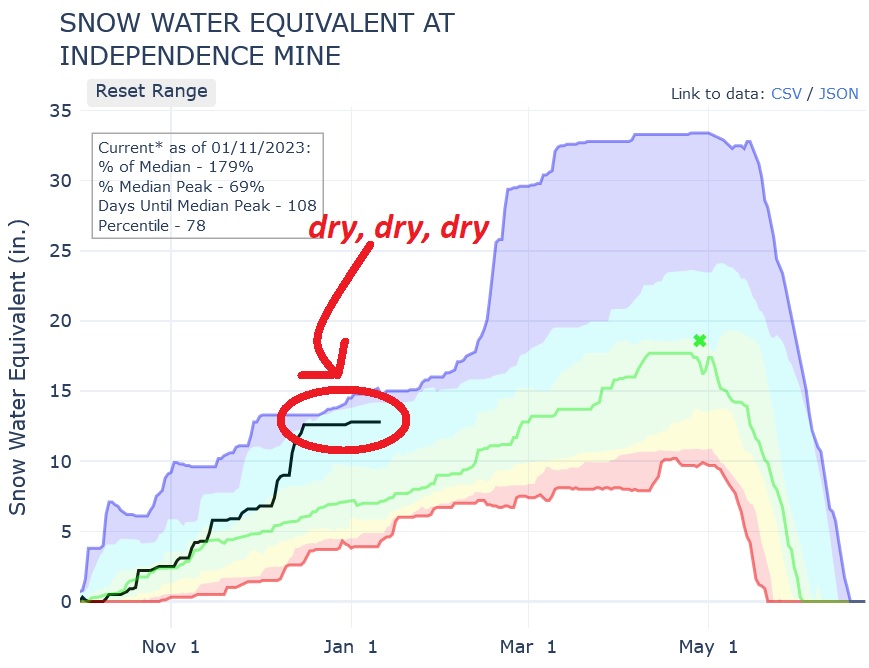
The first event in the layer cake was weeks of dry and relatively cold weather. This extended "drought" is particularly visible on the Independence Mine SNOTEL:

Along with this generally clear and cold weather came faceting of the surface snow as the moisture in the snow was sucked into the atmosphere. Like many physical processes in our world, faceting is driven by gradients (differences). The difference between the relatively warm/wet air in the snow and the relatively cold/dry atmospheric air produces a vapor pressure gradient that drives water vapor through the snowpack and metamorphoses/changes strong round snow crystals into weak square ones. Avalanche.org has a fun animation that describes the process:
Then on top of this layer of sugary surface facets we got our biggest storm cycle of the year. During this cycle the Center Ridge SNOTEL shot up from near the 10th percentile to almost average:

Looking ahead, this weekend's sun does come with some gap winds. I've talked about these a lot this winter and feel like a broken record, but as a reminder, these clear periods often come with wind. This is because the cold, dense and high pressure air of interior AK flows "downhill" towards the relatively warm and low pressure air in the Gulf of AK. These winds favor terrain channels and gaps (i.e. Thompson Pass, Whittier, and Seward); hence Gap Winds. Here's a cool figure from UBC illustrating this:

To ski during these gap wind events the key is to avoid prominent features and channeled terrain such as road corridors and long valleys where the wind can easily flow (i.e. the Sunnyside of Seattle Ridge vs. Goldpan, Tincan Proper vs. The Library, or Arcose Ridge vs. Independence Mine Valley).
THURS - FRI: warm, mostly cloudy, snowy (high confidence).

Not only are the days getting longer, the sun is also rapidly getting higher in the sky. Just like length of day, percent change in height of the sun is much greater here than farther south. Its also fun comparing the angle of the sun across latitudes. Note that at the equator the sun is directly overhead at noon on the equinoxes.

Speaking of the equinox: I'd always thought the equinox is when there is equal day and night. Actually there is a little more than 12 hours of daylight on the equinox. Technically, the equinox is when the plane of the earth's equator passes through the geometric center of the Sun's disk - the moment the center of the visible sun is directly above the equator:

The spring equinox is also when sunrise first comes to the north pole, then the last sunset of the year at the north pole on the autumn equinox - pretty cool!

Archived Outlook - 3.8.2023
THURS - FRI: mostly sunny, windy, moderating temps (high confidence).
Temps drop to a more reasonable range with cold mornings and warm afternoons. Strong winds for the Mat Valley (affecting Hatcher), Anchorage/ER FRange, Portage/Whittier, Seward, Crow Pass, our high peaks, and especially VDZ/Thompson. Sun affecting south-facing slopes that are not cooled by wind.

Turnagain Pass:

Hatcher Pass:

Temperatures are finally starting to "cool down" as we can see on the ECMWF temp forecast for 5,000 ft below. Its pretty wild seeing the ridge of heat encompassing our zone before it finally breaks down tonight.

Speaking of the sun, as it gets higher in the sky (and stronger), so much more terrain is getting direct light! You can really see the difference comparing the Shade Map for the winter solstice and the equinox. On the solstice basically just Goldpan was getting sun, while by the upcoming equinox nearly everything gets some sun! Its a good time to focus on all those classy north facing lines!

With the strong spring sun we are going to keep seeing big diurnal temp swings between cold early mornings and warm late afternoons. Today there was a 42 degree temp swing at Granite Creek!

These swings occur because of the difference in incoming radiation from the sun and outgoing energy from the earth. Even more interesting, the peak temp of the day doesn't occur at noon when the incoming solar radiation is the greatest, but later in the afternoon when the earth has had a chance to cook a little longer. This is well explained by the nice figure below:

THURS - FRI: dropping temps, clearing skies, windy (high confidence).

The weekend sun sure has been so lovely! As my friend Tony put it, it was cold AF in the shade. Here's Nyssa's February entry into the AK hardgirl swimsuit calendar from Saturday in the East Fork of Eklutna - trust me there's a swimsuit under 5 layers of insulation.

We think it was about -10 or -15 °F and blowing 25 mph back there. That's a wind chill of -40 °F...brrrrrrr. With more cold and windy weather coming its fun to take a look at the wind chill chart:

More gap winds - I feel like a broken record! Fortunately these winds will not last for the whole upcoming period, and will be decreasing by Sunday! These midwinter clear/cold events often come with wind. This is because the cold, dense and high pressure air of interior AK flows "downhill" towards the relatively warm and low pressure air in the Gulf of AK. These winds favor terrain channels and gaps (i.e. Thompson Pass, Whittier, and Seward); hence Gap Winds. Here's a cool figure from UBC illustrating this:
To ski during these gap wind events the idea is generally to avoid channeled terrain such as road corridors and long valleys where the wind can easily flow (i.e. the west face of Magnum vs. Goldpan, or Tincan Proper vs. The Library).
As the winds stop stirring the air up on Sunday and early next work week, strong inversions will arrive. These form at night and are driven by cold, dense air flowing downhill while any warmth left at the surface escapes into the atmosphere. Without clouds to act as an insulating blanket more energy escapes into the atmosphere. Here's an old textbook graphic of the process:

Happy March 🌞🌞🌞🌞!!!!!
THURS - FRI: heavy snow, warm, windy (high confidence).
However, the cloud deck was pretty high which is the usual with these clear and calm periods after precip:

Photo: Tom Flynn
Looking into this weekend, the upcoming clear and cold period will bring strong gap winds. These midwinter clear/cold events often come with wind. This is because the cold, dense and high pressure air of interior AK flows "downhill" towards the relatively warm and low pressure air in the Gulf of AK. These winds favor terrain channels and gaps (i.e. Thompson Pass & Whittier); hence Gap Winds. Here's a cool figure from UBC illustrating this:
The key to skiing during these gap wind events is generally to avoid channeled terrain such as road corridors and long valleys where the wind can easily flow (i.e. the west face of Magnum vs. Goldpan, or Tincan Proper vs. The Library). In this bad case the key will probably be to avoid most of the Kenai, Turnagain Arm, and Anchorage Front Range mountains.
Clear and cold periods generally bring inversions. These form at night and are driven by cold, dense air flowing downhill while any warmth left at the surface escapes into the atmosphere. Without clouds to act as an insulating blanket more energy escapes into the atmosphere. Winds can mix out these pools of cold air up, and its going to be windy so expect these inversions to be less widespread than normal. Here's an old textbook graphic of the process:
Lastly, now on the radar you can see the southwest flow that is dumping snow on Hatcher:

As has been well advertised, the Hatcher and FRange snowpacks are fat. But, the Gird/Turny zone is falling behind, and that disparity is only going to get worse with the next couple SW flow events:

Archived Outlook - 2.15.2022

Art by Goldpan Owen
Owen made one error here which is that it should say *Mike avoiding work*, but, regardless the MOST IMPORTANT THING HERE IS THE SUN IS FINALLY COMING OUT. There is high confidence in this upcoming dry period because of strong model agreement:

On a slightly less positive note, you all probably noticed that Windy.com has locked down access to long term forecasts with their Premium subscriptions. We should probably buy a subscription for the backcountry ski group.

This clear and cold period will bring gap winds to the usual spots. These midwinter clear/cold events often come with wind. This is because the cold, dense and high pressure air of interior AK flows "downhill" towards the relatively warm and low pressure air in the Gulf of AK. These winds favor terrain channels and gaps (i.e. Thompson Pass & Whittier); hence Gap Winds. Here's a cool figure from UBC illustrating this:
The key to skiing during these gap wind events is to avoid channeled terrain such as road corridors and long valleys where the wind can easily flow (i.e. the west face of Magnum vs. Goldpan, or Tincan Proper vs. The Library).
This clear period will also bring inversions. These form at night and are driven by cold, dense air flowing downhill while any warmth left at the surface escapes into the atmosphere. Without clouds to act as an insulating blanket more energy escapes into the atmosphere. Winds can mix out these pools of cold air up, so expect the inversions to be weaker where the gap winds are stronger (ie. Portage). Here's an old textbook graphic of the process:
One last thing - I noticed that the Snow Water Equivalent (SWE) at the Wrangell's SNOTELs is at all time highs for the date. Has me thinking about a spring ski trip out there:


Archived Outlook - 2.8.2022
THURS - FRI: cold/clear -> stormy (high confidence).

It was amazing how much soft snow had accumulated there after it had been hard just days before. Additionally, it was a great reminder of just how local mountain weather and conditions are as winds are funneled by terrain: just a few hundred yards away the main drainage was much firmer and wind-affected.

Tomorrow's clear and cold weather will bring moderate gap winds to the usual spots. These midwinter clear/cold events often come with wind. This is because the cold, dense and high pressure air of interior AK flows "downhill" towards the relatively warm and low pressure air in the Gulf of AK. These winds favor terrain channels and gaps (i.e. Thompson Pass & Whittier); hence Gap Winds. Here's a cool figure from UBC illustrating this:
The key to skiing during these wind events is to avoid channeled terrain such as road corridors and long valleys where the wind can easily flow (i.e. the west face of Magnum vs. Goldpan, or Tincan Proper vs. The Library).
Looking towards next week, the confidence in the weather near the PWS is extremely low. This is because there is such high model disagreement with predictions of everything from sun to heavy snow for the western Prince William Sound mountains:

All this snow trickling in just keeps adding up, with the Independence Mine SNOTEL sitting right near the max SWE (snow water equivalent) on record for the date. For that matter, we're getting very close to the median annual peak SWE.

Probably a good time time to start thinking about those Hatcher and Anchorage/Eagle River Front Range objectives! That is, if you aren't already!!!
THURS - FRI: light snow, warm, cloudy (high confidence).
Dirty Details

It was warm, but nothing like the upper 40s that the NWS was predicting. I have no idea where they got those numbers from, there was never any model that showed that kind of extreme heat. Use their forecasts at your own risk.
.jpg)
Skiing out of the windf#*$ed Rabbit Creek drainage into the east side of North Yuyanq’ Ch’ex, it was incredible how the snow immediately turned to pow as soon as we were out of the Anchorage Bowl. The Front Range is a windy place. Check out this difference from wind scoured rocks on the west side...

...to Ben ripping pow just a couple hundred yards east from our wind-scoured wasteland:

Past the Sunday/Monday storm it looks like we are in for more of the warm and cloudy weather that has been plaguing our mountains (and my soul) for the last month.

Fortunately you don't *need* good viz to ski the chutes and couloirs that infest the FRange!
THURS - FRI: clearing skies, moderating warm temps, calming winds (high confidence).
With the ongoing disaster created by the last month of weather around the TurnaGird zone we've continued to work the western edge of the precipitation shield. This time we checked out The Sail and Shaman Dome. Turns out Arctic to Indian is a lot of work with 20 miles of trailbreaking and two bonus mountains thrown in there. Who would have thought...

That being said, stability is not perfect around Ship Creek either. Here's a cool picture from The Sail of a smaller skier-triggered windslab avalanche initiating from Austin's skis.

Oh!! For those who haven't noticed - its actually been snowing at Hatcher! This week's snow brings the Independence Mine SNOTEL close to max on record for the date!

Dirty Details

There's more interesting annual climate stats for Anchorage from the NWS here. Some things that stood out to me for this warm and wet year:
- 2022 was the 7th warmest year on record with an average temperature 1.6 °F above normal!
- New high temp records were set for 12 days in 2022, while only one new low temp record was set!
- The five warmest years on record have all happened since 2015!
- The five coldest year on record all happened before 1974!
- There were above 0 °F temperatures at the Anchorage Airport EVERY DAY in 2022!


We've been trying to manage this weather by skiing a little farther west to where the edges of the storms are just dropping enough snow to soften surface conditions. Here's Cam looking for that sweet spot above Indian Pass:

THURS - FRI: partly sunny, warm, ridgetop winds (high confidence).

There's lots of examples of mongo surface hoar out there on the interwebz, and we often see particularly large hoar frost crystals around creeks where there is an infinite supply of moist air. I like this example of surface hoar from the Crested Butte Avalanche Center, possibly cause it reminds me of the good old days in Colorado.

This upcoming week looks to be pretty similar to the last couple, with the mountains closest to the western Prince William Sound again getting the most snow.

Hatcher is again the big loser where the dry period is all too visible on the SNOTEL daily SWE plot. Thanks to our very wet December, there's still a lot of snow on the ground there, but surface conditions could be...softer.
This weather pattern of snow for Turnagain, Girdwood, and Portage vs. graybird for Hatcher is courtesy of storms hitting our zone with southeasterly winds. It would be nice to get a storm or two with southwesterly winds to refresh surface conditions around Hatcher and the FRange.

THURS - FRI: clearing skies, dropping temps, light winds (high confidence).
Dirty Details
This week of storms has done great things to build up the snowpack around Turnagain - a great start to the new year!!! It was fun watching on satellite imagery as the low pressure of the last storm spun counterclockwise (lows spin clockwise in the Southern Hemisphere) across the Gulf of AK before crashing into the PWS:

As we all know its been warm down low...which has not helped with alders...unless you are an alder, in which case you're probably very happy.
But, the alpine is filling in with the Center Ridge SNOTEL getting close to average! Its actually a little better than shown below too because the SNOTEL plots are from end of day, so it doesn't account for the inch of SWE that fell on Wednesday.

Looking into early next week there is low confidence if it will snow at Turnagain/Girdwood. This is because the models are all over the place on if, when, and how much it will snow:

Most likely is that some light snow will trickle through during the early part of next work week. On the bright side it should be a little colder, so the precip will go further at low elevations.
Archived Outlook - 12.28.2022
THURS - FRI: warm, light winds, light snow (high confidence).
Dirty Details

Confidence is low for this weekend's storm because there is so much uncertainty in just how much precip it will bring. As the NWS put it in their forecast discussion this afternoon: "If there were ever a weatherman`s wish for a New Year`s resolution, it would be with models to just get along and agree with each other." Maybe next year!!! As can be seen in both the GFS and ECMWF ensembles below there is huge spread in the forecast precipitation range:


With these warm storms, Whittier, Portage, Seward, Turny, and Gird need the high winds to wring precipitation out of the air by slamming the moisture into and lifting it over the Chugach/Kenai mountains (orographic lift). Meanwhile Anchorage/Hatcher are in the rain shadow:

Dirty Details

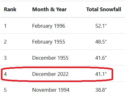
But, the story here over the last week has been the cold temps after the series of storms that pounded our Upper Cook Inlet mountains. These storms have made December 2022 the fourth snowiest month on the record in Anchorage. December will probably finish as the 3rd snowiest month on record, but at this point I wouldn't put any money into bumping into the top two.
The clear skies and cold temps have led to impressive inversions and hoar frost formation:

Weather and terrain factors determine the spatial variability of surface hoar formation. This video does a good dweeby job of briefly describing this:
Time (and gravity) has also led to a lot of settlement in the storm snow. I've really enjoyed watching this settlement in our yard compared to the snow stuck to the fence:

We also classically see this slow deformation and densification of snow in settlement cones around trees, brush, and other veg like in this awesome pic from the Sierra Avalanche Center:

Looking at this coming week, some of our mountains are going to get whacked by the wind on Friday. We are used to the Valdez zone getting the wind, but its notable that the Talkeetnas, which often escape the high, will get hit hard.

And finally, we are past the solstice! My buddy Carp posted this last year, its a hilarious representation of our strange relationship with the sun here in AK.

Archived Outlook - 12.14.2022
THURS - FRI: clearing, temps dropping, moderate wind (high confidence).

Its going to snow hard overnight, but it will be over quickly and Anchorage, Girdwood, and the Valley won't see anything like the bonkers numbers that some of the weather apps and Wunderground have been predicting. Here's an example of this error:

As of last night Anchorage broke the 1989 record of 27.55 inches of liquid precipitation in a year!!! I'm sure we all remember (or would like to forget) July, August, and September. This last storm should be a cherry on top of our new record before the weather dramatically shifts to clear and cold. I have high confidence in this change happening (and hanging around for awhile) because there is such good agreement between models as can be seen on Meteoblue Multimodel:

Archived Outlook - 12.7.2022
Dirty Details
Of course the big story is the band of snowfall that focused on Anchorage:
Figure: National Weather Service
I
was wrong in my forecast last week when I predicted light snowfall
favoring the mountains closest to the Prince William Sound. Not only was
the snowfall not light, it didn't favor that zone! In my defense these
heavy precipitation deformation zone events are really hard to predict a
week out partly because they are such small-scale events. The storm is
really visible in the sudden jump in the Anchorage Hillside SNOTEL:
I
feel like a broken record here (yes that was a high school nickname),
but leading up to the weekend we're gonna get hit by more gaps winds.
These winds will pound the usual victims of
Valdez/Seward/Whittier/Portage, but as shown below they will also hit
the heart of our Turnagain ski terrain and the Mat Valley. When the Mat
Valley winds blow like this they'll bleed over into the Arcose Ridge ski
terrain as well.
Archived Outlook - 11.30.2022
Dirty Details
The key to skiing during these wind events is to avoid the channeled terrain along the road corridors and long valleys where the wind can easily flow (i.e. the west face of Magnum vs. Goldpan).
This same cold weather also works to facet the snow as the moisture is sucked out. Just like most everything else in the world, faceting is driven by gradients (differences over distance or time). The difference between the relatively warm/wet air in the snow and the cold/dry atmospheric air produces a pressure gradient that drives water vapor through the snowpack and changes round snow crystals into square ones. Avalanche.org has a fun animation that describes the process:
Ski season is definitely here and some people have definitely been getting after it (specifically Colin Gordon & William Kincaid). A little bit more snow would always be nice though, so I was interested in how this season-to-date compares to normal for this time of year. Plotting up SNOTEL data for Turnagain and Hatcher, looks like we are off to a pretty average start:
Turnagain (Center Ridge SNOTEL):

Hatcher (Independence Mine SNOTEL):

Archived Outlook - 11.23.2022
Thurs - Fri: moderate temps, light snow, light winds (high confidence).
Thursday
starts out clear and calm before snow and clouds arrive lasting into
Friday. Clouds/snow arrive first for Thompson Pass/Valdez then the rest
of our mountains as the storm moves west. Moderate snow for Thompson
Pass with generally light snow elsewhere. No rain concerns. Winds ramp
up Friday afternoon as the storm departs.
- Hatcher Pass: Montana Peak on mountain-forecast.com
- Anchorage Front Range: Ptarmigan Peak on mountain-forecast.com
- Turnagain/Girdwood: Girdwood on Wunderground
- Valdez/Thompson Pass - Valdez on Wunderground
- Central Alaska Range: Moose's Tooth on mountain-forecast.com
- Tordrillos: Mount Spurr on mountain-forecast.com
- Neacolas: Mount Iliamna on mountain-forecast.com
- Hatcher Pass
- Anchorage Front Range
- Turnagain/Girdwood
- Thompson Pass
- Central Alaska Range
- Tordillo Range
- Neacola Range
- Avalanche Weather Information Forecast Discussion - mountain-specific short-term forecast discussion.
- Short Term Forecast Southcentral AK - most useful, provides specific weather.
- Model Discussion - usually useful, informs confidence in your forecast.
- Long Term Forecast - sometimes useful, provides possible trends.
- Analysis and Upper Levels, Marine Gulf of AK - details and learning opportunities.
- New Snow - Use to figure out what area is favored. Hatcher Pass, Anchorage Front Range, and Turnagain Arm storms are better captured by high resolution models (NAM & ECMWF). Note, Windy uses a 10X conversion from precip to snow, with cold storms (like the recent ones), the Snow/Water ratio will be 15X or higher.
- Winds @ 3000 ft - Surface winds. These require high res, so NAM is best, then ICON and ECMWF, with GFS the worst.
- Winds @ 250 hPa - Jet stream elevation - the weather conveyor belt. When it hits us from the SE it brings precip to western Prince William Sound mountains. As it rotates to the SW it favors precip for Hatcher, Anchorage Front Range, and Thompson Pass. Look to see if the jet stream is coming from as far south as Hawaii for warm Pineapple Express storms. From the N it brings cold and often outflow winds.
- Windy's 10 Day ECMWF and GFS Forecasts - Do the two models agree? Is the forecast changing each time you pull it up? For higher confidence in your forecast look for agreement between the two models and between runs of each model.
- NWS Forecast Discussion (referenced above) - This product is produced twice daily. Read the long term forecast. Does each new forecast discussion say generally the same thing or it changing? Look for the terms "confidence", "agreement" and "differences" throughout the forecast discussion - this will let you how much the Weather Service is trusting the models.
- Meteoblue Ensemble - Farther into the future the model spread will generally grow. The bigger spreads there are for temp, precip, and wind, the less confidence you have in your forecast.
Thanks for introducing me to Meteoblu, this seems to improve on Windy's forecast comparison tool.
ReplyDelete