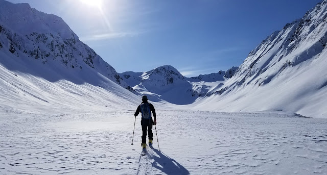
Last June, Nyssa, Hazel, Charlee, Tony, Charlie and I headed north for our solstice pilgrimage to the Arctic. In Fairbanks, we met with Kirk Sweetsir who flew us in his bushplane to where the Hulahula River cuts through the Romanzoff Mountains of the Brooks Range. From there, we worked our way down the Hulahula to the edge of the coastal plain where we portaged to the Okpilak River. We explored the country around the Okpilak Hot Springs then floated the Okpilak to the edge of the coastal plain before one last portage to Kaktovic and our flight home. I think this is a close replica of a trip that Ken Hill, Robin Beebee, Ed Plumb, and Seth Adams did years ago - I'm sure others have done it as well.
The adventure started early on a Saturday June morning in Fairbanks as we dragged ourselves out of bed, injected caffeine into our groggy brains, and Ubered to Wright Air. We dropped off the Charliees and Tony who would fly to Arctic Village in one of Wright's Cessna Grand Caravans where Kirk would double back to get them after dropping us off at the landing strip.
Typical of operations serving rural Alaska, Wrights wasn't open yet, and we left the trio standing outside to figure out finding breakfast while we went looking for Kirk. The Yukon Air hangar was also deserted upon our arrival and it was our turn to work on breakfast while we waited for Kirk. Breakfast was on the way by the time Kirk pulled up in his Subaru. Then we started digging around for the bear spray and fuel he has stashed for us and stuffing our gear into his Cessna 185. Packing was pretty quick and we are soon airborne and leaving Fairbanks behind. As we flew north, the foothills of the Brooks Range begin to grow out of the vast northern coniferous forest. 
The taiga melted away below replaced by surreal barren mountains rising around us. These peaks aren't tall, but they cut into sky with their raw untamed beauty. 
As we passed the continental divide, and flew into the Hulahula watershed, I was filled with excitement to explore this wild place of caribou, pastel colors, and beautiful rivers.

Sunday, March 2, 2025
Okpilak River Packraft - June 2024
Friday, February 28, 2025
Spirit Walker - 2.12.2025
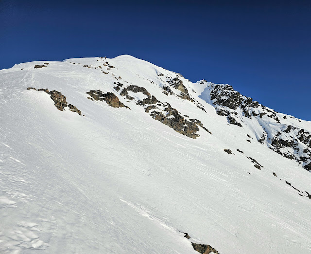
With its beautiful 3,500 vertical foot west face of sustained avalanche terrain rising straight out Mills Creek, Spirit Walker has been on my list for what seems like forever. But, as it has a tendency to do, time has ticked forward without me skiing Spirit Walker or many of the other things on the list.
Before the glorious midwinter ski window of 2025 came to an end, Dan and I drove south out of Anchorage to give the Summit classic a go. Around Twentymile I realized my beacon was not present. Discussions, brainstorming, justifying, and phone calls ensued. We were saved in Girdwood with a loaner beacon from George - thank you so much. Back on track, we were soon leaving the inversion of Canyon Creek behind and skinning up the old mining road.
We left the road behind where the west ridge of Spirit Walker met the mining grade and began to climb up the ridgeline. I'd heard horror stories about trying to navigate this ridge and imagine they are true between the top of Soul Fire and the true summit, but when we dropped into the Soul Fire face we'd encountered nothing but smooth travel on our climb.
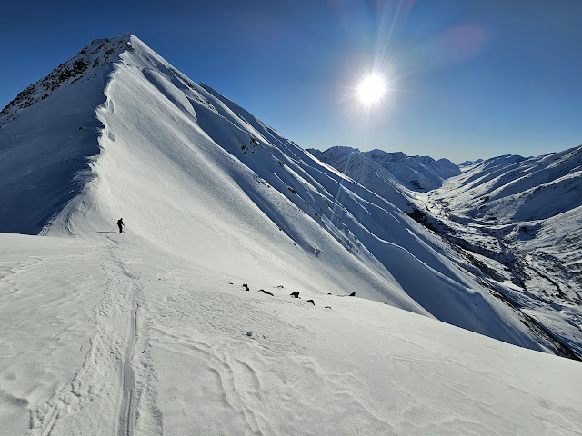
The snow surface had an unpleasant looking texture and it was hard to believe it would ski ok, but a little bit of faith and a few bad turns brought us past the bad wind affect and into really faceted windboard that skied a bit liked corn. I enjoyed the consistent pitch of the ribs of Soul Fire and chased after Dan until we were at the bottom and right under Spirit Walker proper. The detour warmup lap was a great way to maximize the approach to the objective and spend less time in the mega terrain trap of Mills Creek. Stoked on the snow conditions we'd found and what was to come, I continued my hopeless pursuit of Dan as he raced towards the top.
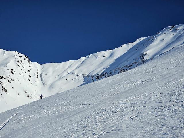
We followed Zack, Claire, and Eli's old skintrack up the south ridge towards the summit. Soaked in sunlight and generally out of significant avalanche terrain, it felt like a great way to get to the peak.

Monday, February 24, 2025
Wolverine Peak Ski - 4.10.2020
Updated in February 2025 to include another great day on Wolverine.
It was April and we were all chomping at the bit. But, I was tired from my solo Bench Peak slog the previous day, and was looking for more vertical and less horizontal. So, Connor, Jordan, and I settled on a circumnavigation of a Turnagain classic - Wolverine.

It was April and we were all chomping at the bit. But, I was tired from my solo Bench Peak slog the previous day, and was looking for more vertical and less horizontal. So, Connor, Jordan, and I settled on a circumnavigation of a Turnagain classic - Wolverine.
We parked at the Eddies lot and followed the familiar trail into the woods before leaving the Iditarod Trail and contouring into Wolverine Creek.
Leaving the hemlock forest behind, we startled two moose who, cautious of hungry bears, high-tailed it up the north face of Eddies. Oddly, the moose were still postholing towards the heavens as we skinned out of sight.

Leaving the hemlock forest behind, we startled two moose who, cautious of hungry bears, high-tailed it up the north face of Eddies. Oddly, the moose were still postholing towards the heavens as we skinned out of sight.

Under Wolverine's iconic northwest-facing catcher's mitt we turned left and started climbing. I'd found good snow in the mid elevations of Bench the previous day, and hoped for the same, but no luck. By the the upper face we were front-pointing on a nearly unskiable mix of rime, ice, icy windboard, and debris.
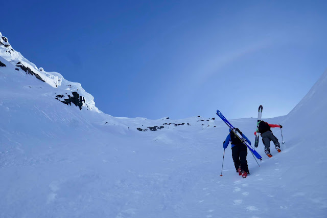
Photo: Connor Johnson

Photo: Connor Johnson
Monday, February 10, 2025
Kickstep Mountain Skiing - 1.25.2015
Updated January 2016 and again February 2025 to include more great days on Kickstep.
There are days that you know that you have everything in your favor: weather, stability, beta, etc. Then, there are days where some pieces of the puzzle might not fit, you don't know how it will turn out.

Josh on the approach up CFR ridge.
Sunday was a day that started out as a question mark, but in the end, it lined up perfectly.

The warm up run.
The question mark was the weather, forecast to be cold and breezy. Cold enough that a wrong turn, avalanche, or crevasse incident could mean hypothermia. We set our sights on a smaller objective: the Library via Tincan Proper.

The Library dwarfed by Kickstep.
There are days that you know that you have everything in your favor: weather, stability, beta, etc. Then, there are days where some pieces of the puzzle might not fit, you don't know how it will turn out.
Josh on the approach up CFR ridge.
Sunday was a day that started out as a question mark, but in the end, it lined up perfectly.
The warm up run.
The question mark was the weather, forecast to be cold and breezy. Cold enough that a wrong turn, avalanche, or crevasse incident could mean hypothermia. We set our sights on a smaller objective: the Library via Tincan Proper.
The Library dwarfed by Kickstep.
Monday, January 13, 2025
Prince William Sound Picture Project
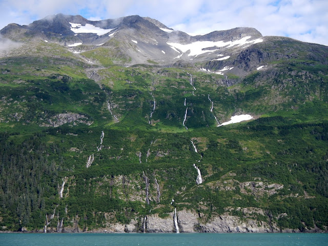
I spent the summer of 2013 working on a fishery research vessel in Alaska's Prince William Sound. This was a truly formulative experience that changed me forever and bound the PWS to my soul. Over the years there have been so many beautiful moments that stood out from a larger story or adventure. After a decade hiatus, I'll continue updating this post with images from these beautiful moments.
2013
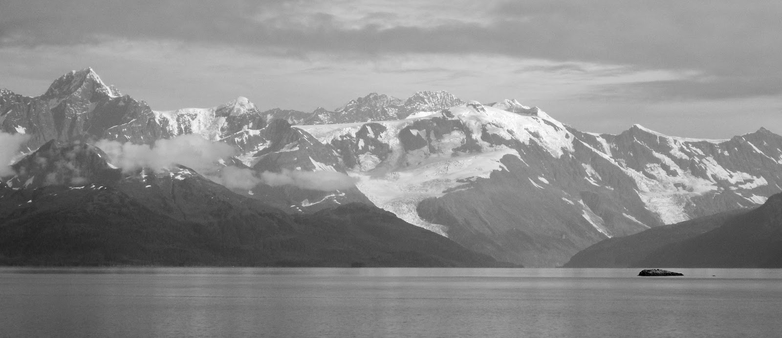
Looking north from Esther Rock, the entrance to College Fjord, Port Wells, is visible in the distance. Esther Rock means different things to different people. For the commercial fishermen, it is often the boundary of one of the salmon fisheries in the Sound. For others, it is a floating "internet cafe" of the Sound.

Glaciers are essentially mass balance problems - they transport snow and ice from higher elevations to lower elevations where it can melt. These Passage Canal glaciers extends over such a short elevation range; I love how even this minuscule change in elevation and distance is enough to produce ice dynamics. They are also rapidly disappearing.

Some people call those who live in Whittier WhitIdiots, those who live there part time are Half-Wits. But, how much of a dimwit can you be if you to choose live in a place that is not only so beautiful, but also has skiing 12 months of the year?
2013
Looking north from Esther Rock, the entrance to College Fjord, Port Wells, is visible in the distance. Esther Rock means different things to different people. For the commercial fishermen, it is often the boundary of one of the salmon fisheries in the Sound. For others, it is a floating "internet cafe" of the Sound.
Glaciers are essentially mass balance problems - they transport snow and ice from higher elevations to lower elevations where it can melt. These Passage Canal glaciers extends over such a short elevation range; I love how even this minuscule change in elevation and distance is enough to produce ice dynamics. They are also rapidly disappearing.

Some people call those who live in Whittier WhitIdiots, those who live there part time are Half-Wits. But, how much of a dimwit can you be if you to choose live in a place that is not only so beautiful, but also has skiing 12 months of the year?

Monday, January 6, 2025
Aleutian Picture Project
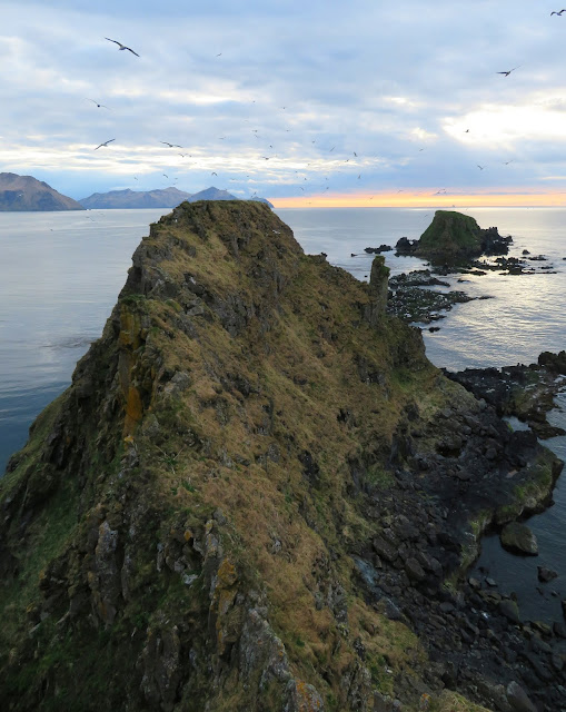
The Aleutian Islands are a chain of 14 large volcanic islands, and 55 smaller ones extending in an arc westward 1,200 miles from the Alaskan Peninsula towards the Kamchatka Peninsula. It is a gnarly world of strong wind, heavy rain, ubiquitous fog, and people that probably aren't like you.
In my early 30s, I spent 5 years working on contaminated site cleanup projects in the Aleutians. Now I work on coastal engineering projects there; sometimes we even visit for fun. Like the Prince William Sound and Kanuti Picture Projects, this post is made up of unique and memorable moments that stand out.
The islands are a punishing land, but a place of abundance. They are a major breeding ground for seabirds who nest on steep cliffs and rely on the rich marine environment for food. During the summer months, the archipelago becomes a vital stop for migratory species traveling between North America and Asia. The Aleutian cackling goose is an endemic subspecies of the Canada goose, notable for its smaller size and adapted to the harsh world of the Aleutians. Raptors including peregrine falcons, eagles, and hawks also call these windswept rocks home. The islands are affected by introduced species including cattle, caribou, foxes, and rats: the ecosystems and animals are visibly different on islands with introduced mammals.
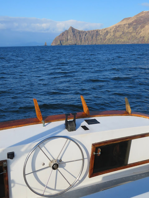
Aboard the C/V Miss Alyssa on the passage from Dutch Harbor to a project on Unalga Island, we encountered something unusual for the Aleutians: blue skies, light winds and calm seas. Dutch Harbor averages 80 inches of rain, 250 rainy days, and 150 days of fog per year. Meanwhile, powerful Pacific storms batter the islands throughout the year with gale-force winds, typhoons, and dangerous storm surges.
With the exception of some stunted willows, the vast majority of the chain is devoid of native trees. On some of the islands, there are a few coniferous trees left over from the Russians. Aleutian conifers, some up to two hundred years old, rarely reach even 10 feet tall because the winds here like to snap off anything taller.
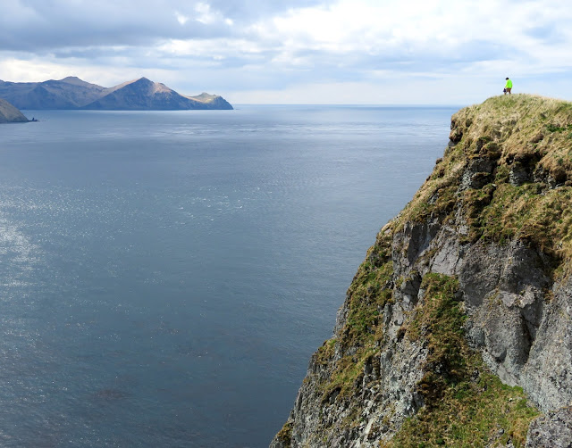
The islands are a punishing land, but a place of abundance. They are a major breeding ground for seabirds who nest on steep cliffs and rely on the rich marine environment for food. During the summer months, the archipelago becomes a vital stop for migratory species traveling between North America and Asia. The Aleutian cackling goose is an endemic subspecies of the Canada goose, notable for its smaller size and adapted to the harsh world of the Aleutians. Raptors including peregrine falcons, eagles, and hawks also call these windswept rocks home. The islands are affected by introduced species including cattle, caribou, foxes, and rats: the ecosystems and animals are visibly different on islands with introduced mammals.

Aboard the C/V Miss Alyssa on the passage from Dutch Harbor to a project on Unalga Island, we encountered something unusual for the Aleutians: blue skies, light winds and calm seas. Dutch Harbor averages 80 inches of rain, 250 rainy days, and 150 days of fog per year. Meanwhile, powerful Pacific storms batter the islands throughout the year with gale-force winds, typhoons, and dangerous storm surges.

With the exception of some stunted willows, the vast majority of the chain is devoid of native trees. On some of the islands, there are a few coniferous trees left over from the Russians. Aleutian conifers, some up to two hundred years old, rarely reach even 10 feet tall because the winds here like to snap off anything taller.

Subscribe to:
Posts (Atom)