
How To Forecast:
1 Minute
- Hatcher Pass: Montana Peak on mountain-forecast.com
- Anchorage Front Range: Ptarmigan Peak on mountain-forecast.com
- Turnagain/Girdwood: Girdwood on Wunderground
- Thompson Pass: Meteorite Mountain on mountain-forecast.com
- Central Alaska Range: Moose's Tooth on mountain-forecast.com
- Tordrillos: Mount Spurr on mountain-forecast.com
- Neacolas: Mount Iliamna on mountain-forecast.com
5 Minutes
Use Meteoblue Multimodel to see differences in magnitude and timing between models for sun, precip, and temp. For wind, different models have different resolution - think number of pixels in a picture - resolution affects wind forecast, so just look for relative windiness over a week. Confidence in your forecast will be higher if the different models agree. Check back on Meteoblue every day to see if the models are consistently forecasting the same weather - if the forecast is different each time you check then the confidence in your forecast will decrease.
- Hatcher Pass
- Anchorage Front Range
- Turnagain/Girdwood
- Thompson Pass
- Central Alaska Range
- Tordillos
- Neacolas
Use the Southcentral Alaska Mountain Forecast and the NWS Point Forecast for the Rain/Snow line - they are imperfect products, but so is rain line forecasting.
15 Minutes
- Short Term Forecast Southcentral AK - most useful, provides specific weather.
- Model Discussion - usually useful, informs confidence in your forecast.
- Long Term Forecast - sometimes useful, provides possible trends.
- Analysis and Upper Levels, Marine Gulf of AK - details and learning opportunities.
- New Snow - Use to figure out what area is favored. Hatcher Pass, Anchorage Front Range, and Turnagain Arm storms are better captured by high resolution models (NAM & ECMWF). Note, Windy uses a 10X conversion from precip to snow, with cold storms, the Snow/Water ratio will be 15X or higher.
- Winds @ 3000 ft - Surface winds. These require high res, so NAM/HRRR are best, then ICON and ECMWF, with GFS the worst.
- Winds @ 250 hPa - Jet stream elevation - the weather conveyor belt. When it overruns us from the SE it brings precip to western Prince William Sound mountains and the Tordillos/Neacolas. As it rotates and overruns to the SW it favors precip for Hatcher, Anchorage Front Range, Thompson Pass, and the Central Alaska Range. Look to see if the jet stream is coming from as far south as Hawaii for warm Pineapple Express storms. From the N it brings cold and often outflow winds.
Long Term - Should I do a Fly-In Trip???
- Windy's 10 Day ECMWF and GFS Forecasts - Do the two models agree? Is the forecast changing each time you pull it up? For higher confidence in your forecast look for agreement between the two models and between runs of each model.
- NWS Forecast Discussion (referenced above) - This product is produced twice daily. Read the long term forecast. Does each new forecast discussion say generally the same thing or it changing? Look for the terms "confidence", "agreement" and "differences" throughout the forecast discussion - this will let you how much the Weather Service is trusting the models.
- Meteoblue GFS Ensemble and ECMWF Meteogram - Farther into the future the model spread will generally grow. The bigger spreads there are for temp, precip, and wind, the less confidence you have in your forecast and the more prepared you need to be to shovel and hunker down!
Archived Outlook - 3.23.2022
Thurs – Fri: stormy, warm, windy (high confidence).

With these warm storms, Whittier, Portage, Seward, Turny, and Gird need the high winds to wring precipitation out of the air by slamming the moisture into and lifting it over the Chugach/Kenai mountains (orographic lift). Meanwhile Anchorage/Hatcher are in the rain shadow:
Thurs – Fri: showery, cloudy, warm (high confidence).HEAVY snow (warm, windy everywhere) favoring the mountains closest to the western PWS (Whittier/Portage) then drying out as you move away from there with Hatcher just getting wind and Thompson getting light snow. Rain near the Turnagain Pass road level. Winds everywhere.
Weekend: showery, partly cloudy, warm (high confidence).
Showers for Turny/Gird and especially Whittier/Portage. Partly sunny elsewhere, with the most sun the farther away you are from the western PWS. Rain showers during the day near sea level along Turnagain Arm. Ridgetop winds. Sun affect on south slopes touched by the sun.
Early Next Week: coastal snow, dry inland, warm (low confidence).
Moderate snow for Turny/Gird and especially Whittier/Portage Mon into Tues; rain at sea level. Low confidence in drying for the western PWS mountains on Wed. Light snow for Thompson Pass; showery for the Anchorage FRange; dry at Hatcher. Moderate winds. Sun affect on south slopes touched by the sun.
Dirty Details
Wowie!!! This is a big Turnagain/Girdwood/Whittier storm that will leave Hatcher high and dry. That is courtesy of strong winds blowing from the southeast that heavily favor the western Prince William Sound:


Like I've talked about before this is pretty typical climatologically (and why there are huge glaciers at sea level in the PWS) as can be seen in this Alaska Annual Precipitation Map:

With these warm storms, Whittier, Portage, Seward, Turny, and Gird need the high winds to wring precipitation out of the air by slamming the moisture into and lifting it over the Chugach/Kenai mountains (orographic lift). Meanwhile Anchorage/Hatcher are in the rain shadow:

Archived Outlook - 3.16.2022
Thurs – Fri: light snow, cloudy, warm (high confidence).Light snow favoring the mountains closest to the western PWS (Whittier/Portage) then drying out as you move inland with Hatcher just getting clouds. Rain near sea level. Ridgetop winds.
Weekend: showery, partly cloudy, warm (high confidence).
Showers for Turny/Gird and especially Whittier/Portage. Partly sunny elsewhere, with the most sun Sunday, and moving away from the western PWS and toward Hatcher. Rain near sea level along Turnagain Arm. Ridgetop winds. Sun affect on south slopes touched by the sun.
Early Next Week: sun + snow + clouds, moderate temps (low confidence - wow hard forecast!).
Mon: dry for Hatcher & the Anchorage FRange with increasing clouds and showers (insignificant accumulation) as you get close to the PWS. Strong inversions for the usual cold holes (Portage, Gold Mint, Granite Creek) and cold mornings . Moderate wind for the FRange, Mat Valley, and Thompson Pass. Sun affect on south slopes.
Tues/Wed: Hatcher will be dry and partly sunny transitioning to clouds and light snow for Turny/Gird and especially Whittier/Portage. Moderate winds. Sun affect on south slopes touched by the sun.
Dirty Details
Wow the days are rapidly getting longer! Yesssss. Not only are the days longer, but the sun is getting higher in the sky, and so much more terrain is getting sun! You can really see the difference comparing the Shade Map for the solstice and the equinox. On the solstice basically just Goldpan was getting sun, while by the upcoming equinox basically everything gets some sun! Its a good time to focus on all those classy north facing lines!

Speaking of the equinox: I'd always thought the equinox is when there is equal day and night. Actually there is a little more than 12 hours of daylight on the equinox. Technically, the equinox is when the plane of the earth's equator passes through the geometric center of the Sun's disk - the moment the center of the visible sun is directly above the equator:

The spring solstice is also when sunrise first comes to the north pole, followed by noon at the north pole on the summer solstice, then the last sunset of the year at the north pole on the autumn equinox - pretty cool!
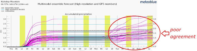
Holy guacamole this Mon - Wed forecast was hard! I spent an hour on it alone. For reference usually I can get the whole weekly forecast done and published in an hour and a half. It was particularly hard because of the difference in weather each day, the difference in wx across our zone, and disagreement between the models. In the big picture its not really that big of a deal - its not going to be splitter bluebird, and its not going to be nuking the whole time - its these little differences that are the hardest to concisely forecast. To give you an idea, below is the Turnagain output from Meteoblue:

Archived Outlook - 3.9.2022
Speaking of the equinox: I'd always thought the equinox is when there is equal day and night. Actually there is a little more than 12 hours of daylight on the equinox. Technically, the equinox is when the plane of the earth's equator passes through the geometric center of the Sun's disk - the moment the center of the visible sun is directly above the equator:
The spring solstice is also when sunrise first comes to the north pole, followed by noon at the north pole on the summer solstice, then the last sunset of the year at the north pole on the autumn equinox - pretty cool!
Holy guacamole this Mon - Wed forecast was hard! I spent an hour on it alone. For reference usually I can get the whole weekly forecast done and published in an hour and a half. It was particularly hard because of the difference in weather each day, the difference in wx across our zone, and disagreement between the models. In the big picture its not really that big of a deal - its not going to be splitter bluebird, and its not going to be nuking the whole time - its these little differences that are the hardest to concisely forecast. To give you an idea, below is the Turnagain output from Meteoblue:
Archived Outlook - 3.9.2022
Light snow Thurs with moderate winds, precip favoring the mountains closest to the western PWS (Whittier/Portage), precip decreasing to showers moving away from western PWS and into Fri. Rain near sea level.
Weekend: drying, moderating temps, sun affect (high confidence).
Clouds and snow showers Sat clearing for a beautiful Sunday! Clearing last and least completely for Portage/Whittier, while first and most moving towards Hatcher and Thompson. Ridgetop winds especially for the Anchorage FRange and Mat Valley. Sun affect on south slopes on Sunday.
Early Next Week: dry, cool temps, sun affect (moderate confidence).
Cold mornings with the spring sun warming the afternoons. Mon and Tues will be beautiful!!! Low confidence in light snow Wednesdayish for Turny/Gird/Seward/Portage/Whittier. Strong inversions for the usual cold holes (Portage, Gold Mint, Granite Creek).
Dirty Details
We've all been noticing the glorious return of the sun, it feels noticeably longer every day. Here's a cool plot from MrReid.org showing the dramatic percentage change in daylight that happens especially in northern latitudes right now:

We all know that the length of day varies much more up here in the north, but this animation from Visual Capitalist really hammers it home:
As the skies clear next week, we can expect cold mornings, with afternoons warmed by the spring sun. This is because there will be no clouds to provide night time insulation to keep the warm air in. I've posted this figure before, and it continues to be relevant. Clouds trap energy in the atmosphere by reflecting longwave radiation:

As objective season arrives its time to take a look at the state of our snowpack. ITS FAT!!! Hatcher Pass in particular is getting into unchartered territory.

With the fat snowpack especially around the Talkeetnas and the Anchorage Front Range its a good time to think about those dream lines that aren't always in, but might be now!
Archived Outlook - 3.2.2022
Thurs – Fri: snowy and warm (high confidence).More snow! Thurs morning brings a quick shot of heavy precip for Whittier/Portage, Gird/Turny do well, Thompson Pass gets some, decreasing towards Hatcher left high and dry. Showers persist for the mountains near the PW Sound through Fri. No rain Thurs, rain near sea level Fri. Ridgetop winds.
Weekend: snowy -> clearing, warm, sun affect (high confidence).
Do I hear an echo? More snow, with all of our mountains receiving moderate snowfall on Sat then drying/clearing Sunday. On Saturday rain will rise above sea level for Turnagain Arm and Whittier. Ridgetop storm winds on Sat will be replaced by increasing outflow winds especially for the Anchorage FRange on Sunday. Warm temps and the spring sun will cook south slopes on Sunday.
Early Next Week: dry, warm, sun affect (moderate confidence).
DRY weather!!! Highest confidence of clear skies on Monday and generally clearer inland (Anchorage, Hatcher, Talkeetna). Big temp swings with cold mornings and warm afternoons. Sun affect on south slopes. Inversions for Gold Mint, Portage, Granite Creek, etc. Strong outflow winds possible for the Anchorage Front Range and Thompson Pass.
Dirty Details
This week's exciting news is the addition of a new model to Windy!!! The High Resolution Rapid Refresh (HRRR) is a very high resolution model with a grid resolution of only 3 km (compare to the high res NAM's resolution of 12 km). Additionally its updated hourly - the NAM, ECMWF, GFS, and ICON are only updated twice or four times daily. Check out what Windy has to say about the addition of the HRRR.First off, this high resolution is great because it can actually see small scale terrain features like mountains and valleys as opposed to the course scale of models like the GFS which just smooth everything out. This difference can be seen in the upcoming precip forecast.

This high resolution will be particularly useful for us for forecasting snow at Hatcher (the "little" Talkeetnas don't stand out well in the course models), and for anticipating the big precip differences that we have been seeing lately between Girdwood and Turnagain
The high res of the HRRR will also be really helpful in forecasting winds, which like precipitation can be really variable over relatively small distances. For example check out how on Thursday morning the HRRR really picks up in the high winds in the Anchorage FRange and Portage, while the majority of our ski terrain experiences far less wind. Pretty rad.

Looking toward next week's spring weather, we are going to start seeing big diurnal temp swings between cold early mornings and warm late afternoons.

These swings occur because of the difference in incoming radiation from the sun and outgoing energy from the earth. Even cooler, the peak temp of the day doesn't occur at noon when the incoming solar radiation is the greatest, but later in the afternoon when the earth has had a chance to cook a little longer. This is well explained by the nice figure below:

Archived Outlook - 2.23.2022
Thurs – Fri: stormy, windy, warm (high confidence).MORE STORM, but this one is different favoring the mountains of the western Prince William Sound. Whittier/Portage gets pounded, Turnagain/Girdwood do great, Thompson Pass does ok, Hatcher left out of the fun. High winds and warm with rain reaching the Turnagain Pass road level.
Weekend: partly cloudy, warm, sun affect (high confidence).
The massive storm moves out, with clearing most complete at Hatcher and showers lingering for Turny/Gird/Thompson Pass and anything close to the PWS. Light winds. Warm temps and the ever intensifying spring sun will cause sun affect on any south slopes that the sun touches.
Early Next Week: partly cloudy, warm, sun affect (moderate confidence).
Finally DRY weather!!! With the caveat that clouds hang on, especially for Turny/Gird/Thompson and the PWS where showers will filter thru Mon-Wed. Low confidence in the days of these showers. Clearer inland for Anchorage and Hatcher. Light ridgetop winds with sun affect on south slopes.
Dirty Details
Its been crazy watching the recent Cook Inlet colossuses riding southwest flow pound Hatcher Pass with HEAVY snowfall again and again as they rapidly push through. There was the Thursday night storm:
AND then there was the Monday storm:

Its not over quite yet, but now we are switching from storms riding SW flow to one riding SE flow. This is the kind of storm that heavily favors the mountains close to Whitter and Portage, with the National Weather Service calling for up to 8 inches of rain there. That translates to about 70 inches of snow for the mountains right next to the western PWS. This is the kind of storm that is why there are massive glaciers over there!

With these warm storms, Whittier, Portage, and Turnagain/Girdwood need the high winds to wring precipitation out of the air by slamming the moisture into and lifting it over the Chugach/Kenai mountains (orographic lift). Meanwhile Anchorage/Hatcher are in the rain shadow:
Archived Outlook - 2.16.2022
Thurs – Fri: heavy snow, warm, moderate winds (high confidence).
The next intense and fast moving storm is upon us!!! Hatcher gets pounded, Thompson Pass and the Anchorage FRange do great, and the north side of Turnagain Arm does well (especially Falls Cr, Girdwood to a lesser extent). Warm with rain easily reaching 1,000 feet, hopefully not too much higher.
Weekend: break in the storms, warm, sun affect (high confidence).
A break in the storms! Clearing most complete at Turnagain and least at Hatcher. Sat driest with showers trickling back in Sunday. The recent precip and light weekend winds mean clouds and fog will linger in valleys. Warm temps and intensifying spring sun will cause sun affect on south slopes that the sun touches.
Early Next Week: snow, warm temps (moderate confidence).
More snow! Low confidence in precip intensity and where is favored, but again likely favoring Hatcher/Thompson with moderate to heavy snow. All our mountains will get snow Monday into Tuesday with rain at low elevations then likely drying out into Wednesday.
Dirty Details
Storms on the conveyor belt of southwest flow continue to pound the Upper Cook Inlet! Looking at the precip record at Hatcher Pass's Independence Mine SNOTEL, we can see the snowpack shooting up with these recent storms and that is just going to continue today - its going to be a fat spring.
Southwest flow favors the mountains of the Upper Cook Inlet (and will again tonight) because the jet stream blowing from the SW smashes the storms into the Talkeetnas, lifts them, and wrings maximum moisture out of the sponge that is the clouds.

Hatcher Pass isn't the only zone that does well with this SW flow. Thompson Pass and Cordova will get hammered, and the mountains on the north side of the Turnagain Arm will do well too. This is basically the opposite of storms blowing out of the SE that favor Portage, Turnagain, and Girdwood.

Thurs – Fri: warming temps, clouding up, arriving light snow (high confidence).
Thursday will start cold (and clear for Turnagain) as the night's winds depart and light snow returns. Low (but non-zero!) accumulations for all of our mountains by the end of Fri. Ridgetop winds, no rain concerns.
Weekend: light/moderate snow, warm temps, ridgetop winds (high confidence).
More snow! But this time favoring Hatcher and Thompson Pass with moderate snow while Turnagain just gets showers after Friday night. Rain/snow line right around sea level for Girdwood, Portage, and Seward.
Early Next Week: more snow, warm temps (low confidence).
You guessed it - more snow! Low confidence in precip intensity and where is favored, but likely light snowfall favoring Hatcher Pass with moderate snow. All our mountains will get snow, but there will be lulls for different area at different times. Wind with each pulse of precip. Rain at sea level close to the Prince William Sound.
Dirty Details
The one thing I missed in last week's forecast was the little freezing rain event that occurred in the Anchorage Front Range on Sunday. Everybody remembers the unusual "drizzle crust" event last year at Hatcher where supercooled water had no nuclei to form an ice lattice around. In contrast, Sunday's event was a much more classic simple case of rain falling on a below freezing surface (snow) and...freezing! Check out the NWS graphic below on the different types of winter precipitation:

Moving on to this week, temperatures are plunging as we get a short intermission from onshore flow with winds briefly switching to blow offshore. Pretty cool to see the bottom fall out of the thermometer on the Wx stations tonight!

After Thursday's brief sunny break we are back into the stormy pattern. All these storms sure have been good for building up our snowpacks! Looking at the SNOTEL summary, the SWE in all of the Anchorage ski zones is at or above average!

Archived Outlook - 2.2.2022
Thurs – Fri: light snow, moderate temps, moderate winds (high confidence).Light snow across the zone with partial clearing Friday at Turnagain. Winds highest Thursday for Portage, Turnagain, and the Mat Valley. No rain concerns.
Weekend: light/moderate snow, warm temps, moderate winds (moderate confidence).
The wet pattern continues with snow thru the weekend across our zone! Expect breaks/lulls in the snowfall over the weekend. Turny, Gird, Portage, and Thompson will do the best (with rain at sea level), but Hatcher and the Anchorage Frange will also pick up snow.
Early Next Week: more snow, moderate temps (low confidence).
Snow continues Mon - Wed! Low confidence in precip intensity and where is favored, but the best bet is moderate snowfall favoring the mountains closest to the PWS. All our mountains will get snow, but there will be lulls for different area at different times. Wind with each pulse of precip. Rain possible at sea level.
Dirty Details
Our prayers were answered and we got our expected weather window on Sunday and Monday! One thing that I missed in my forecast last week was the thiiiicccckkkk layer of valley clouds. Given how calm the winds were and all the recent precipitation I should have expected that - I'll try to do better next time!

That being said, above the clouds it sure was lovely. Nyssa ripping up TT43 on Sunday:
After these couple of lovely days of sun, the wet pattern has returned and looks to stay that way for awhile. As can be seen by comparing the long term GFS and ECMWF precip forecasts below, there isn't great agreement (low confidence) and the SWE numbers aren't huge:


But expect the snow to just keep trickling in and stacking up!
That being said, above the clouds it sure was lovely. Nyssa ripping up TT43 on Sunday:
 |
After these couple of lovely days of sun, the wet pattern has returned and looks to stay that way for awhile. As can be seen by comparing the long term GFS and ECMWF precip forecasts below, there isn't great agreement (low confidence) and the SWE numbers aren't huge:
But expect the snow to just keep trickling in and stacking up!
Archived Outlook - 1.26.2022
Thurs – Fri: moderate temps, moderate/heavy snow (high confidence).Heaviest snow for mountains closest to Whittier/Portage with Turny/Gird doing well then decreasing amounts as you move away from the Prince William Sound with Hatcher getting the least. Relatively light winds, and snow to near sea level! Accumulations will be good cause of persistent snowfall!
Weekend: drying out, dropping temps (high confidence).
Drying out/clearing up first and most completely for Hatcher, with everywhere likely beautiful by Sunday! Near Whittier will be the last and least complete to dry/clear. Moderate winds for the Mat Valley, Thompson road corridor, and the Anchorage FRange with ridgetop winds elsewhere all peaking Sunday.
Early Next Week: cool temps, snow possible (low confidence).
Monday likely dry and mostly sunny, with clouds likely moving in and snow possible Tues-Wed. Low confidence in snowfall intensity and where is favored, but at this point light snowfall is the best guess.
Dirty Details
Another week of memorable weather for our zone! First off we all know how warm it got in Anchorage, but in case you forgot here's a reminder. This is because of the chinook winds I talked about last week.

These winds and temps came courtesy of tropical moisture riding strong winds out of the south and southeast. The pineapple express of Monday's storm was clearly visible on satellite imagery:

Both of last week's storms are highlighted on the Sunburst weather station history by their high wind speeds:

With these warm storms, Turnagain/Girdwood need these high winds to wring precipitation out of the air by the wind slamming the moisture into and lifting it over the Chugach/Kenai mountains (orographic lift).
On the other hand, this Thursday/Friday storm is different (and better!) because cold air from the north will team up with the mountains to help to lift the moisture and produce more widespread snowfall (and less rain!):

These winds and temps came courtesy of tropical moisture riding strong winds out of the south and southeast. The pineapple express of Monday's storm was clearly visible on satellite imagery:
Both of last week's storms are highlighted on the Sunburst weather station history by their high wind speeds:
With these warm storms, Turnagain/Girdwood need these high winds to wring precipitation out of the air by the wind slamming the moisture into and lifting it over the Chugach/Kenai mountains (orographic lift).
On the other hand, this Thursday/Friday storm is different (and better!) because cold air from the north will team up with the mountains to help to lift the moisture and produce more widespread snowfall (and less rain!):

Archived Outlook - 1.19.2022
Thurs – Fri: warm, wet, and windy storm arriving (high confidence).Clouds arrive Thursday ahead of the approaching storm and its rapidly warming temps. Thurs night into Friday precip heaviest for Portage/Whittier/Seward, moderate for Turny/Gird/Thompson Pass then decreasing as you move towards Hatcher. Rain to the Turnagain Pass road level.
Weekend: warm, light snow, cloudy (high confidence).
Light precip all weekend for Turnagain/Girdwood/Thompson - heavier precip the closer you are to the Prince William Sound and dryer towards Hatcher. Rain to the Turnagain Pass road level; hot in Anchorage. Moderate ridgetop winds.
Early Next Week: warm and stormy (moderate confidence).
Heavy, windy precip Monday into Tuesday for the mountains above the PWS (especially Whittier, Seward, Portage with Turny/Gird/Thompson doing well too), and dryer towards Hatcher. Rain to the Turnagain Pass road level; hot in Anchorage. Drying out with moderating temps on Wed.
Dirty Details
This evening (Wednesday night) we can see today's storm dissipating and moving off to the east on the Middleton Island radar as snowfall comes to an end for our zone:

After a brief break tomorrow, we are back into the pattern of wet and warm with heavy precip for the mountains close to the Prince William Sound, while the Anchorage Front Range and Hatcher are left out of the fun. Its a 10 day forecast, so the exact numbers are not important, but you can see that the heavy precip is coming and where its focused:

This ongoing pattern of precip heavily favoring Turnagain, Girdwood, and Thompson Pass over Hatcher and the Anchorage FRange is climatologically typical (and why there are huge glaciers at sea level in the PWS) as can be seen in this Alaska Annual Precipitation Map:
The other big story is how warm its going to get in Anchorage and the Matsu Valley. This will be caused by the relatively dry chinook winds that heat up as they flow downhill over the Chugach after dumping their moisture on the upslope side. From Accuweather:

Finally, as the days keep getting longer its pretty cool to check out the Shade Map that somebody recently posted (in case you missed it) in the Backcountry Ski Addiction Group. It really highlights those special places that get the sun midwinter, and hide from it in the spring!
After a brief break tomorrow, we are back into the pattern of wet and warm with heavy precip for the mountains close to the Prince William Sound, while the Anchorage Front Range and Hatcher are left out of the fun. Its a 10 day forecast, so the exact numbers are not important, but you can see that the heavy precip is coming and where its focused:
This ongoing pattern of precip heavily favoring Turnagain, Girdwood, and Thompson Pass over Hatcher and the Anchorage FRange is climatologically typical (and why there are huge glaciers at sea level in the PWS) as can be seen in this Alaska Annual Precipitation Map:
The other big story is how warm its going to get in Anchorage and the Matsu Valley. This will be caused by the relatively dry chinook winds that heat up as they flow downhill over the Chugach after dumping their moisture on the upslope side. From Accuweather:

Finally, as the days keep getting longer its pretty cool to check out the Shade Map that somebody recently posted (in case you missed it) in the Backcountry Ski Addiction Group. It really highlights those special places that get the sun midwinter, and hide from it in the spring!

Archived Outlook - 1.12.2022
Thurs – Fri: stormy, warm, windy (high confidence).Tomorrow's warm storm brings heavy precip and high winds both petering off Fri. Snow heaviest in the mountains above Whittier and Seward decreasing moving away from the PWS. Thompson will do OK, Turny/Gird well, then decreasing moving west 'til leaving Hatcher dry. Rain to near the Turnagain road level.
Weekend: moderating temps, light snow, mostly cloudy (high confidence).
Light snow Sat and Sat night with some clearing Sunday. Rain line near sea level. Ridgetop winds.
Early Next Week: moderate temps, some sun, some clouds (moderate confidence).
Mon will be the best ski weather of this forecast with high confidence of dry with some sun. Tues likely dry then light snow (low confidence) possible Wed. Driest/clearest for Hatcher. Light winds.
Dirty Details
The Sunday/Monday storm came in a little smaller than I had hoped, but on the bright side the next one is almost here as can be seen on the satellite imagery with the Pineapple Express plume of moisture already approaching from near Hawaii:
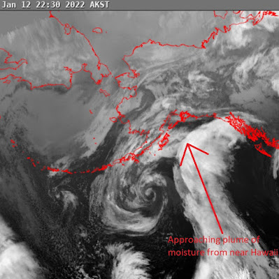
Just like last time, this storm will bring the most precip to the mountains closest to the western Prince William Sound. The reason for this is that the storm will have winds flowing from the southeast which smash moisture into the mountains above Whittier, Seward, and Portage and on towards Turnagain:

Meanwhile this SE flow leaves the inland side (Anchorage Front Range/Hatcher) dry, which is nicely explained in this figure I edited from the Teton Valley News:
As the moisture of this SE-flow-storm is wrung out of the air by the mountains it will then warm as it descends over the mountains and into town. From Accuweather.
Archived Outlook - 1.5.2022
Thurs – Fri: cold, clear, windy in specific areas (high confidence).A couple more days of the same before the pattern change. Windy Fri (although not as windy as its been) for the Mat Valley, Thompson, and Hatcher. Ridgetop winds elsewhere. Inversions for the usual cold holes (Portage, Granite Cr, Gold Mint).
Weekend: moderating temps, increasing winds, snowy (high confidence).
Saturday will be the transition day as clouds and light snowfall arrive and temps begin to rise with Sunday's incoming storm. The storm will favor the mountains closest to the western Prince William Sound - heavy snowfall for Whittier/Portage, moderate snow for Turny/Gird, less for Thompson, and Hatcher left high & dry. No rain concerns.
Early Next Week: warm, stormy (moderate confidence).
Precip continues and continues to favor the mountains closest to the western PWS. Precip (and wind) likely heaviest Monday then continuing into Wednesday. By Wed the storm totals for Turny/Gird could be several feet of snow. Rain likely at sea level.
Dirty Details
We've talked about it before, but given how extreme the winds hammering the Mat Valley have been its worth mentioning again. These midwinter clear and cold periods often bring wind. This is because the cold, dense and high pressure air of the interior flows "downhill" towards the relatively warm and low pressure air in the Gulf of AK. These winds favor terrain channels and gaps (especially the Mat Valley, Thompson, Seward, and Whittier). Here's a cool figure from UBC illustrating this:

Which area gets hit the hardest is dependent on the specific location of the low pressure that the winds are flowing towards.
Speaking of wind, this is a good time to throw in a wind chill chart. The warm surface of our skin heats the air around it, creating an insulating boundary layer of warm air next to our skin. Wind disrupts this layer, allowing cooler air to replace the warm air against the surface. The faster the wind speed, the more readily the surface cools.

Of course, wind chill temperature only applies to us living critters. It doesn't apply to inanimate objects like rocks. The wind may increase the rate at which a rock cools off, but if its 20 degrees with a wind chill of -5 then the rock will still behave as if it’s 20 degrees. Your exposed skin, on the other hand, will frostbite as quickly as if the temperature was actually -5 degrees.
This cold and clear weather also works to facet the little bit of soft snow we have left as the moisture is sucked out of the snow. Just like everything else in the world, faceting is driven by gradients (differences). The difference between the relatively warm/wet air in the snow and the cold/dry atmospheric air produces a pressure gradient that drives water vapor through the snowpack and changes round snow crystals into square ones. Avalanche.org has a fun animation that describes the process:
Long term its likely that we stay in this warm and stormy pattern favoring precip for Portage, Turnagain, and Girdwood. Precision in a 10 day forecast isn't realistic, but nice to see these big numbers!

Speaking of wind, this is a good time to throw in a wind chill chart. The warm surface of our skin heats the air around it, creating an insulating boundary layer of warm air next to our skin. Wind disrupts this layer, allowing cooler air to replace the warm air against the surface. The faster the wind speed, the more readily the surface cools.
Of course, wind chill temperature only applies to us living critters. It doesn't apply to inanimate objects like rocks. The wind may increase the rate at which a rock cools off, but if its 20 degrees with a wind chill of -5 then the rock will still behave as if it’s 20 degrees. Your exposed skin, on the other hand, will frostbite as quickly as if the temperature was actually -5 degrees.
This cold and clear weather also works to facet the little bit of soft snow we have left as the moisture is sucked out of the snow. Just like everything else in the world, faceting is driven by gradients (differences). The difference between the relatively warm/wet air in the snow and the cold/dry atmospheric air produces a pressure gradient that drives water vapor through the snowpack and changes round snow crystals into square ones. Avalanche.org has a fun animation that describes the process:
Long term its likely that we stay in this warm and stormy pattern favoring precip for Portage, Turnagain, and Girdwood. Precision in a 10 day forecast isn't realistic, but nice to see these big numbers!
Archived Outlook - 12.29.2021
Thurs – Fri: moderate temps, light snow, light winds (high confidence).The rest of the work week will start clear then cloud up with the arrival of light snow Thurs night. Light snow continuing thru Fri. Snowfall won't be enough to improve surface conditions. But at least no rain! Inversions Thursday morning for the usual cold holes (Portage, Granite Cr, Gold Mint). Ridgetop winds.
Weekend: dropping temps, clearing skies, increasing winds (high confidence).
Cloudy Saturday with partial clearing and cold temps on Sunday. Strong winds (especially Sunday) for the Anchorage Front Range, the Mat Valley (think Castle Mtn coolie), Hatcher Pass, the Thompson Pass road corridor, and Seward. Elsewhere, moderate winds for long valleys, passes, and ridgetops.
Early Next Week: cold, sunny, windy in specific areas (high confidence).
Strong winds Monday decreasing towards Wednesday for the Anchorage FRange, the Mat Valley, Hatcher Pass, and the Thompson Pass road corridor. Decreasing ridgetop winds elsewhere. Cold temps. Inversions for the usual cold holes.
Dirty Details
Well. Well. Well. As our dear friend Neil likes to say: "The Chugach giveth and the 'Gach taketh away"...but, in this case its all of Southcentral AK taking away!!! My forecast last week called for warm temps, but I erroneously used the word "snow". We all know how that went. I missed forecasting last year's freezing rain event too, so clearly need to up my game in this front.
This picture from @sarahmasco sums up what's happened to all of our surfaces:

Its going to snow across our zone tomorrow night, but not enough to significantly soften conditions in our mountains. On the bright side, even a couple inches should go a long way to improve the XC skiing in town! Ice skaters may be less stoked about this.

From Sunday into the next work week, there is rare high confidence in the long term forecast. This high confidence is because of amazingly good agreement across the ensemble forecast.

Another way of visualizing this is EMCWF's Probability of No Precipitation map. For our zone, there is a greater than 95% probability that there will be no precipitation between Monday and Wednesday!

Long term forecasts have such low value, and I am probably going to stick my foot in my mouth for doing this, but it looks like the dry weather will likely stick around at least thru the end of the next week (especially for Hatcher Pass) as is shown by the ENS Meteogram:

Archived Outlook - 12.22.2021
Thurs – Fri: windy, clearing, temps dropping (high confidence).This picture from @sarahmasco sums up what's happened to all of our surfaces:
Its going to snow across our zone tomorrow night, but not enough to significantly soften conditions in our mountains. On the bright side, even a couple inches should go a long way to improve the XC skiing in town! Ice skaters may be less stoked about this.
From Sunday into the next work week, there is rare high confidence in the long term forecast. This high confidence is because of amazingly good agreement across the ensemble forecast.
Another way of visualizing this is EMCWF's Probability of No Precipitation map. For our zone, there is a greater than 95% probability that there will be no precipitation between Monday and Wednesday!
Long term forecasts have such low value, and I am probably going to stick my foot in my mouth for doing this, but it looks like the dry weather will likely stick around at least thru the end of the next week (especially for Hatcher Pass) as is shown by the ENS Meteogram:
Archived Outlook - 12.22.2021
Light snow for Hatcher tonight will be followed by high winds for all our mountains tomorrow - unusually Thompson Pass will be less windy. Friday skies will clear, temps will drop, and winds will calm. Inversions for the usual cold spots (Portage, Granite Creek, Gold Mint).
Weekend: cloudy, warming, snow (high confidence).
Expect a cloudy weekend with moderate snowfall favoring Hatcher on Sunday. Hatcher will be the snowiest and cloudiest, followed by the Anchorage Frange, then by Turnagain/Girdwood, with Thompson Pass being the driest. Light winds.
Early Next Week: warm temps, mostly cloudy, stormy (low confidence).
Monday will be quiet, calm, and partly cloudy before a potentially strong storm moves in Tues/Wed. Again this storm looks to favor Hatcher, followed by the Anchorage Frange, then by Turny/Gird, with Thompson Pass being the driest. Confidence in timing/strength of this storm is low.
Dirty Details
We are past the solstice! My buddy Carp posted this, its a hilarious representation of our strange relationship with the sun here in AK.

In all seriousness, a bit more daylight sure will be nice! Not only are the days getting longer, the sun is is getting higher in the sky. In fact, as shown below, the percent change in height of the sun is much greater here than farther south. Its also fun comparing the angle of the sun across latitudes. Note that at the equator the sun is directly overhead at noon on the equinoxes. Also, note that the sun currently only makes it 5.5 degrees above the horizon 😱.

The weather pattern we are experiencing is governed by an Omega block. Its called an Omega block because the jet stream winds around a high pressure paired with two low pressures in the shape of an omega:

As the blocking high pressure wiggles around it lets small storms blowing from the west sneak into our zone. This storm track favors the Tordrillos and Alaska Range, and Hatcher does the best for us...but as you can see the Omega Block doesn't let much snow through.

Next week's storm is promising because it could feature upper level winds at the jet stream elevation blowing out of the southwest and stuffing moisture into Hatcher Pass. These SW winds force the moist air to rise over the Talkeetna Mountains and wring extra moisture out of the sky.

In all seriousness, a bit more daylight sure will be nice! Not only are the days getting longer, the sun is is getting higher in the sky. In fact, as shown below, the percent change in height of the sun is much greater here than farther south. Its also fun comparing the angle of the sun across latitudes. Note that at the equator the sun is directly overhead at noon on the equinoxes. Also, note that the sun currently only makes it 5.5 degrees above the horizon 😱.

The weather pattern we are experiencing is governed by an Omega block. Its called an Omega block because the jet stream winds around a high pressure paired with two low pressures in the shape of an omega:
As the blocking high pressure wiggles around it lets small storms blowing from the west sneak into our zone. This storm track favors the Tordrillos and Alaska Range, and Hatcher does the best for us...but as you can see the Omega Block doesn't let much snow through.
Next week's storm is promising because it could feature upper level winds at the jet stream elevation blowing out of the southwest and stuffing moisture into Hatcher Pass. These SW winds force the moist air to rise over the Talkeetna Mountains and wring extra moisture out of the sky.
Archived Outlook - 12.15.2021
Thurs – Fri: moderate temps, light snow, light wind (high confidence).Very light snow Thursday followed by some sun on Friday. Snowfall will be the highest near Whittier.
Weekend: moderate temps, light snow, winds in specific areas (high confidence).
Very light snow Saturday followed by some sun on Sunday. Snowfall will be the highest for Hatcher. Ridgetop winds. Winds peak Sat night: worst for Seward and Thompson Pass road corridor followed by Whittier/Portage then the Anchorage Front Range.
Early Next Week: moderate temps, light snow, increasing wind (moderate confidence).
Some sun Monday followed by light-moderate snow Monday night-Tuesdayish favoring Hatcher. Then increasing winds and dropping temps likely towards Wednesday. Winds will be the worst for the usual spots (Whittier/Portage, Seward, Thompson Pass, Anchorage Front Range), but everywhere looks to be affected.
Dirty Details
Some cloud cover over the upcoming period will be part of the moderate temperature equation, this is because clouds provide insulation for the atmosphere by trapping energy by reflecting longwave radiation:

The next week's weather is pretty boring, so its a good time to look at the status of our snowpack, its about what you'd expect with areas favored by southeast-flow storms (mountains close to the western Prince William Sound) doing well - Alyeska and Turnagain are both around 150% of average! While zones that are favored by southwest flow not doing so well (Hatcher and Thompson).

Interestingly, Hatcher's Independence Mine SNOTEL isn't that far below average at 94% of water year-to-date median precipitation despite the term "low tide" being thrown around a lot lately (and it definitely does look bumpy up there!). But, with as close as we are to "average" the snow depth at Hatcher right now is really just a reflection of how its a pretty continental snowpack that gets less snow as can be seen in this Alaska Annual Precipitation Map:
Despite its relatively thin snowpack, there sure has been some good early season skiing up at Hatcher:

The next week's weather is pretty boring, so its a good time to look at the status of our snowpack, its about what you'd expect with areas favored by southeast-flow storms (mountains close to the western Prince William Sound) doing well - Alyeska and Turnagain are both around 150% of average! While zones that are favored by southwest flow not doing so well (Hatcher and Thompson).
Interestingly, Hatcher's Independence Mine SNOTEL isn't that far below average at 94% of water year-to-date median precipitation despite the term "low tide" being thrown around a lot lately (and it definitely does look bumpy up there!). But, with as close as we are to "average" the snow depth at Hatcher right now is really just a reflection of how its a pretty continental snowpack that gets less snow as can be seen in this Alaska Annual Precipitation Map:
Despite its relatively thin snowpack, there sure has been some good early season skiing up at Hatcher:
Archived Outlook - 12.8.2021
Thurs – Fri: stormy, moderate temps (high confidence).Heavy snowfall (with wind) Thursday favoring the mountains closest to the western Prince William Sound and the eastern Kenai Peninsula (Turnagain, Girdwood, Seward, and especially Whittier and Portage). Storm tapering off Friday. No rain concerns.
Weekend: cold, dry, windy (high confidence).
Skies clearing and temps PLUMMETING thru the weekend. Sunday will be colder and clearer. The worst winds will be through Thompson Pass, Seward, and the Anchorage Front Range. Hatcher will be the least impacted by the wind. Inversions for East Anchorage and Granite Creek.
Early Next Week: moderating temps and winds, possible (moderate confidence).
Monday starts out clear and bitterly cold with strong inversions in the usual spots and with moderating winds for Thompson Pass, Seward, and the Anchorage Front Range. Tuesday and Wednesday temps moderate with the arrival of clouds and likely light snowfall for our mountains. Snowfall likely to again favor the mountains closest to the western Prince William Sound and the eastern Kenai Peninsula.
Dirty Details
The upcoming storm will favor the mountains of the eastern Kenai Peninsula and those closest to the western Prince William Sound while leaving Anchorage and the Talkeetnas dry. The reason for this is that the storm winds will be southeasterly, as shown in the example below:
Moving into the weekend, it will be freeeeeezing and bringing wind with it. These midwinter clear and cold periods often bring wind. This is because the cold, dense and high pressure air of the interior flows "downhill" towards the relatively warm and low pressure air in the Gulf of AK. These winds favor terrain channels and gaps (i.e. Thompson Pass); hence Gap Winds. Here's a cool figure from UBC illustrating this:

The key to skiing during these wind events is to avoid the channeled terrain along the road corridors and long valleys where the wind can easily flow.
Tuesday into Wednesday my forecast confidence degrades because I am not sure how much snowfall is coming. This is because of increasing differences in model runs. Modeled accumulated precipitation for Turnagain is shown below; the purple lines stay tight until Tuesday when some solutions start to rapidly diverge towards possibly heavier snowfall.

Southeast winds produce precip near the coast (ie Turnagain/Girdwood/Whittier/Valdez) and leave the inland side dry and cloudy, which is nicely explained in this figure I edited from the Teton Valley News:
Moving into the weekend, it will be freeeeeezing and bringing wind with it. These midwinter clear and cold periods often bring wind. This is because the cold, dense and high pressure air of the interior flows "downhill" towards the relatively warm and low pressure air in the Gulf of AK. These winds favor terrain channels and gaps (i.e. Thompson Pass); hence Gap Winds. Here's a cool figure from UBC illustrating this:
The key to skiing during these wind events is to avoid the channeled terrain along the road corridors and long valleys where the wind can easily flow.
Tuesday into Wednesday my forecast confidence degrades because I am not sure how much snowfall is coming. This is because of increasing differences in model runs. Modeled accumulated precipitation for Turnagain is shown below; the purple lines stay tight until Tuesday when some solutions start to rapidly diverge towards possibly heavier snowfall.
Archived Outlook - 12.1.2021
Thurs - Fri: clearing, cold temps, light winds (high confidence).
Plummeting temperatures as skies clear across our zone. Windy for Seward, the Thompson Pass road corridor, Whittier, and to a lesser extent the Anchorage Front Range; ridgetop winds elsewhere. Inversions and valley fog, especially Portage, Granite Creek, and East Anchorage.Weekend: increasing clouds, temps, and winds (high confidence).
Saturday starts out COLD and clear with light winds and inversions/valley fog especially in the usual cold pools. Then temps rise and clouds and wind arrive Sunday with the incoming storm.
Early Next Week: moderate temps, stormy (low confidence).
Stormy Monday/Tues drying into Wednesday with everywhere in our zone picking up snow. Precip totals will be moderate, but snowfall will be boosted by cold air in place. Confidence is low, not on whether it will snow, but where will be favored.
This is my first outlook of the winter, so here's how I go about about figuring out where to ski:
1 Minute
Hatcher Pass - Montana Peak on mountain-forecast.com
Anchorage Front Range - Ptarmigan Peak on mountain-forecast.com
Turnagain/Girdwood - Girdwood on Wunderground
5 Minutes
Use Meteoblue Multimodel to see differences in magnitude and timing between models for sun, precip, and temp. For wind, different models have different resolution - think number of pixels in a picture - resolution affects wind forecast, so just look for relative windiness over a week. Confidence in your forecast will be higher if the different models agree. Check back on Meteoblue every day to see if the models are consistently forecasting the same weather - if the forecast is different each time you check then the confidence in your forecast will decrease.
- Hatcher Pass - Skyscraper Mountain
- Anchorage Front Range - Harp Mountain
- Turnagain/Girdwood - Kern Creek
Use the Southcentral Alaska Mountain Forecast for the Rain/Snow line - its an imperfect product, but so is rain line forecasting.
15 Minutes
- Short Term Forecast Southcentral AK - most useful, provides specific weather.
- Model Discussion - usually useful, informs confidence in your forecast.
- Long Term Forecast - sometimes useful, provides possible trends.
- Analysis and Upper Levels, Marine Gulf of AK - details and learning opportunities.
- New Snow - Use to figure out what area is favored. Hatcher Pass, Anchorage Front Range, and Turnagain Arm storms are better captured by high resolution models (NAM & ECMWF). Note, Windy uses a 10X conversion from precip to snow, with cold storms (like the recent ones), the Snow/Water ratio will be 15X or higher.
- Winds @ 3000 ft - Surface winds. These require high res, so NAM is best, then ICON and ECMWF, with GFS the worst.
- Winds @ 250 hPa - Jet stream elevation - the weather conveyor belt. When it hits us from the SE it brings precip to western Prince William Sound mountains. As it rotates to the SW it favors precip for Hatcher, Anchorage Front Range, and Thompson Pass. Look to see if the jet stream is coming from as far south as Hawaii for warm Pineapple Express storms. From the N it brings cold and often outflow winds.
Long Term - Should I get ahead on work to ski next week???
- Windy's 10 Day ECMWF and GFS Forecasts - Do the two models agree? Is the forecast changing each time you pull it up? For higher confidence in your forecast look for agreement between the two models and between runs of each model.
- NWS Forecast Discussion (referenced above) - This product is produced twice daily. Read the long term forecast. Does each new forecast discussion say generally the same thing or it changing? Look for the terms "confidence", "agreement" and "differences" throughout the forecast discussion - this will let you how much the Weather Service is trusting the models.
- Meteoblue Ensemble - Farther into the future the model spread will generally grow. The bigger spreads there are for temp, precip, and wind, the less confidence you have in your forecast.
No comments:
Post a Comment