
4.1.2020
Thurs – Fri: warm, small storm (high confidence).Thursday night's storm will bring snow to all our mountains. Snow totals won't be big, but enough to improve current firm snow conditions. Rain possible at sea level. Drying Friday afternoon with light gap winds for Turnagain Arm, Whittier, and Seward.
Weekend: warm, Sunday storm (high confidence).
Saturday is the calm before the next storm. Sunday's storm will favor Hatcher Pass, the Anchorage Front Range will do OK, and Turnagain Pass will do the worst. Snow totals in inches. Rain at sea level. Winds increasing with Sunday storm.
Early Next Week: moderate temps, Tuesday storm possible (low confidence).
Sunday's storm will continue showers at Hatcher into Monday. Monday will be moderately windy for all mountains. There is high confidence in cooling temps, but low confidence in another possible storm Tuesday. Wednesday towards the weekend looks to be dry.
Dirty Details
We are very confident in tomorrow's storm as the models agree and have been predicting it consistently for awhile now as can be seen in the GFS model's precipitation forecasts for the Susitna Valley:
Snowfall on Thursday will be enhanced for Hatcher and the Front Range by upper level winds blowing out of the southwest and wringing more water out of the air:

Again, Sunday's storm will be reinforced by upper level southwest flow:


Guessing at Tuesday snow totals is a shot in the dark. The ECMWF is currently forecasting a foot for Turnagain. After Tuesday the confidence in a drying trend improves.
Last Week
This last week went largely as expected, though I could have been a more precise. The Sunburst weather station provides a good summary of what happened over the last week:
First, temps dropped as flow shifted and brought cold air from the north. Late last work week I had expected light snow, but we just got clouds. Then came the weekend which brought calm conditions down south, wind to Hatcher, cold mornings, and warmer afternoons. The avalanche cycle at Hatcher was triggered by the strong winds that were very evident on the Marmot Wx station:

These winds were due to air flowing "downhill" from high pressure over the interior towards the low south of Juneau:

We took advantage of the rare calm conditions around Portage to nab Isthmus and Carpathian this weekend. So did a lot of other folks (nice work Charlie, Jimmy, Chris, Cam, Dane, Brandon, Trish, and whoever else got Carpathian!) Isthmus:

Carpathian:

Although we did see solar warming in the afternoons it wasn't strong enough to soften the snow surface as I had expected. And, now, as we expected clouds have arrived in our zone.
Archived Outlook - 3.25.2020
Thurs – Fri: warm, dry Thurs, small storm Fri (high confidence).
Thursday will be a spring day with gaps winds impacting Turnagain Arm/Portage/Whittier, Seward, and the Tordillos/Neacolas; there will be solar impact on south aspects. Friday will cloud up with the arrival of a small storm; all mountains will see light snow. Insignificant snow accumulation at sea level. Temps trending down.
Weekend: moderate temps, clearing over weekend, windy in Talkeetnas (high confidence).
Trending colder and clearer over the weekend as the Friday night storm clears out. Expect cold mornings and warm afternoons as skies clear. There will be solar impact on south aspects. Sunday will likely be windy in the Talkeetnas.
Early Next Week: moderate temps, dry, winds calming (moderate confidence).
Temps continue to drop into Monday before beginning to rebound. Expect cold mornings and warm afternoons. Monday will likely be windy in the Talkeetnas. There will be solar impact on south aspects. More clouds Tuesday into Wednesday with light snow possible near coast.
Dirty Details
There is high confidence that we are at the beginning of a cooling trend. Confidence is high due to good model agreement:
On Thurdsay expect gap winds for the Turnagain Arm/Portage/Whittier corridor. These winds are well resolved by the ECMWF and NAM models because they have small grid cells and corresponding finer resolution:

Even with sunny and warm afternoons over the next week, we can expect cold mornings. This is because as skies clear, there are no longer clouds to provide night time insulation to keep the warm air in. I've posted this figure recently, but it continues to be relevant. Clouds trap energy in the atmosphere by reflecting longwave radiation:

After the Friday night storm moves out we can expect a clearing trend going into next week (especially away from the coast). As seen here for Hatcher Pass, there is good model agreement in dry weather:

Last Week
This last week went much as expected. After Thursday's quick and warmstorm brought a small round of precipitation to our region, skies cleared and winds calmed. We took advantage of the calm winds to for Byron on Friday:
Saturday brought the expected storm, and as we forecast, accumulations were in inches, not feet. Hatcher did the best as usual with SW flow. Sunday brought clear skies and gusty gap winds. Channeled terrain experienced the worst wind, although the ridgelines of Hatcher were gusty too. One thing that I thought was cool is that Saturday's storm came with so little wind that old tracks were well preserved under the new snow. For example, check out Erin breaking trail on a seemingly intact skinner:

Photo: Brandon Schmidt
Again, so far this work week has gone as we expected. Its been warm (actually just hot), with Granite Creek hitting 46 F this afternoon! Last night into today clouds moved thru bringing light snow to areas around the Cook Inlet favored by west flow (west side of Talkeetnas, Tordrillos, and Neacolas).
As we speak, clearing skies are visible on the radar (or out the window) as cooler and drier air arrives from the north:

Thurs – Fri: stormy Thursday night, warm, mild winds (high confidence).
The Thursday night storm will favor the Talkeetnas, Tordrillos, and Neacolas. Accumulations will be light as the storm is fast moving with clearing on Friday. There will be solar impacts on south aspects when the sun comes out.
Weekend: stormy Saturday, clearing Sunday, mild temps (high confidence).
The entire zone will see snowfall on Sat followed by clearing Sunday. Accumulations will be in inches, not feet. There will be solar impacts on south aspects when the sun comes out. On Sunday, expect gap winds through Turnagain Arm, Portage, Whittier, and especially Seward.
Early Next Week: glorious Monday, warm, mild wilds (moderate confidence).
There is high confidence that Monday will be dry. Tuesday into Wednesday expect some clouds, with light snowfall possible for the Talkeetnas, Tordrillos, and Neacolas.
Dirty Details
Thursday night's storm will come out of the west, and as such will favor the western slopes of the Tordillos, Neacolas, and Tordillos:

On Sunday, as the Saturday storm exits our region to the southeast, expect moderate gap winds, especially through north-south oriented gaps like Seward, Thompson Pass, and through the Tordillos/Neacolas:

Moving into next week, there is high confidence that Monday will be glorious due to good model agreement. Tuesday into Wednesday expect some clouds, and the possibility for snowfall for Hatcher, Tordillos, and Neacolas. There is low confidence in this snowfall due to poor model agreement:

The models are trending away from precip for Tues/Wed. I think dry weather is more likely, especially for Turnagain Pass.
Last Week
WOW! Isn't March amazing?!?! The last week went as we expected. Clear skies, warming temps, and strong solar impact lead to the avalanche that closed the Hatcher Pass road on Thursday afternoon. But, we still found cold smoke on north aspects above the Goldmint lot on Thursday night:
Temperatures warmed into the weekend, but without much wind to scoop them out, inversions remained strong until the afternoon sun could break them down. The inversion was clearly visible hanging above the valley from Hatcher on Saturday:

However, even with the strong sun, the snow stayed great in the shade.:
Then, on Tuesday, the storm we had been expecting zipped through our region. It was fast moving, and came from the southwest, favoring Hatcher and leaving light accumulations in its wake. It was cool to see the storm racing up Cook Inlet on the radar:

Thurs – Fri: gorgeous, warming temps, cold nights, calm winds (high confidence).
Gap winds calming on Thursday. Cold mornings. Sun affect on solar aspects. Inversions in the usual spots (Portage, Granite Cr, East Anchorage).
Weekend: glorious, warm days/cold nights, calm winds (high confidence).
Cold mornings. Sun affect on solar aspects. Inversions in the usual spots.
Early Next Week: warm, clouding up in Tuesday, small storm (moderate confidence).
A small storm is possible Tuesday. Don't expect big numbers, hard to say what specific areas will be impacted at this point.
Dirty Details
Wow! Spring is here! And with spring are coming warming temps. There is high confidence in a trend of warming temperatures because of good agreement between models:

Along with these warming temps are days of sun. Again there is good model agreement:

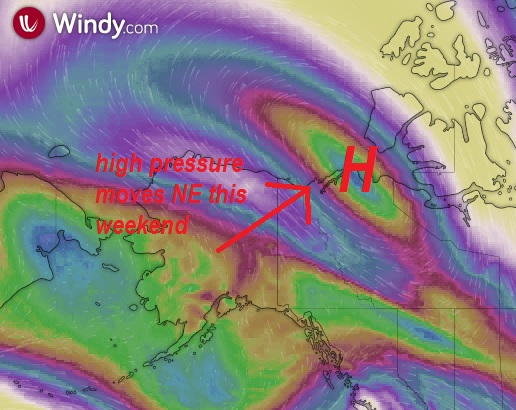
These warming temps are courtesy of the high pressure that will develop over our region. As opposed to low pressure which spins counterclockwise, highs spin clockwise:

During these upcoming warm days we can still expect cold mornings courtesy of the clear skies that don't provide the same insulation as clouds. Here's a nice figure from NOAA illustrating how clouds trap energy:
Last Week
This last week started with clear skies and soft snow courtesy of our last southwest flow event. We found some great snow (and cold temps) at Hatcher on Thursday and Friday:
Then the weekend came, bringing with it another southwest flow snowfall event. We all know what that brought. NWS produced a nice animation of accumulating snowfall at the Marmot webcam. If you look thru the imagery you can also see the snow settling.

Snowfall lasted into Monday with intense snow showers even on Monday night:

These showers were also visible on the Kenai Radar:

Once the storm moved out our zone experienced gap winds thru the repeat offenders (Turnagain Arm, Seward, Whittier, Valdez, Copper River):

As of this evening the winds are calming down leaving behind great after work ski weather (thanks to Andy for opening this line up for the year!):

Archived Outlook - 2.26.2020
Thurs – Fri: gorgeous, cool, light winds (high confidence).
Hatcher and the interior will clear up before Turnagain and mountains near the Prince William Sound. Sun affect on steep south slopes. Mild inversions for the usual suspects (East Anchorage, Granite Cr, Portage). Cooler inland. Light gap winds (Seward, Whittier, Thompson Pass, Mat/Su valleys).
Weekend: small storm, moderate temps (high confidence).
A small storm will bring light snowfall to all of our mountains. Snowfall will likely be in inches, not feet. There shouldn't be rain concerns. Accumulation likely begins late Saturday. Cooler inland. Winds remain light.
Early Next Week: cool, dry, light winds (moderate confidence).
Skies clear as the weekend storm moves out. Sun affect on steep south slopes. Mild inversions in the usual places. Cooler inland. Valley fog possible. Wind and clouds may increase on Wed.
Dirty Details
We are over 10 hours of daylight! And with all that light is coming some glorious spring weather. Not only are we getting more solar radiation, but its lasting longer. Below are solar radiation plots for Anchorage on the solstice and now (horizontal ground in blue, vertical surface in red, and a surface perpendicular to the sun in black):


To conceptualize how much more energy is hitting the snow (and producing sun affect) compare the area under the curves particularly how little energy hits flat ground in the middle of winter.
This weekend's storm will be enhanced by the support of upper level winds blowing from the southwest and wringing moisture out of the air as they lift it over the mountains:

Early next week should return to lovely spring weather as the storm track moves to the south:

Last Week
The finale in the series of storms hitting our zone came on Thursday. This storm could be seen bringing precipitation to our region on southerly flow on the radar:
Even after the Thursday storm, intense snow-showers continued into the weekend. The NWS forecast discussion summarized the physics of the showers (yes, I am paraphrasing):
With a moist environment remaining from the last warm front,
the cold wind is helping to maintain widespread light snow
for the Kenai, the Anchorage, Mat-Su Valleys and PWS.
By Sunday low clouds were all that was left of last week's moisture. Above it was gorgeous:

And Monday brought the splitter day we were expecting/waiting for:

Complete with incredible snow quality:

By Monday night, significant winds in the Talkeetna mountains were produced by cold air racing down the Susitna and Mat valleys towards the low south of Kodiak:

As this low moved into the Gulf of Alaska it brought a precipitation pattern classic of SE flow where mountains near the western Prince William Sound see snowfall, but the rest of our zone stays dry:

Archived Outlook - 2.19.2020
Thurs – Fri: warm, snowy (high confidence).
Thursday will be snowier and windier. Snowfall will favor mountains close to the Prince William Sound; rain possible at sea level. Light snowfall will continue for all mountains through Friday.
Weekend: drying, cooling, calm winds (high confidence).
Skies will trend clearer and temps will drop over the weekend. Expect snow showers for all mountains. Light gap winds in channeled terrain.
Early Next Week: gorgeous then storm possible (low confidence).
High confidence Monday will be beautiful; sun affected snow possible on steep solar aspects, and light gap winds. Low confidence in a coastal storm midweek.
Dirty Details
The next storm is on our doorstep. And can be seen arriving from the southwest on the radar:

This storm will favor the mountains closest to the Prince William Sound. Here is the storm total snowfall forecast from the ECMWF model:

Moving towards the weekend we will switch to a showery snowfall regime before clearing Sunday into Monday. Models have been very consistent forecasting this clearing trend, so confidence is high.
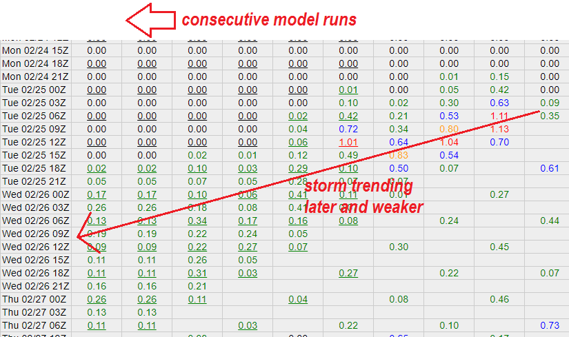
Confidence decreases after Monday. Tues/Wed snowfall is possible for mountains near the coast. However, there is disagreement between the models about this storm. Additionally, the GFS model has been trending the storm later and weaker for the Kenai Mountains:
I wouldn't put any money on the strength of this storm.
Last Week
Wowwwwww! Last week ended even better than expected with clear skies, calm winds, and soft snow. We had a great time exploring couloir-land east of town.
Thanks to everyone who broke trail!

Of course Turnagain sounded soft too. Interestingly, there were reports of the beginnings of sun affect down there. We're now gaining almost 6 minutes of light a day, days are four hours longer and the sun is 3X as high in the sky as at the solstice. Here's a cool plot from Iowa State showing these extreme changes:

After the sun came the snow. As we expected, everywhere got snow. This was courtesy of two lows: one in the Bering pumping cold air towards us, and one in the Gulf supplying moisture. You can see the two lows spinning below:

Precipitation was impressive with snowfall rates over an inch an hour. Here's a cool figure from CNFAIC showing a day of intense snowfall:

Despite this last big storm the Mt Alyeska SNOTEL is still at only 50% of median. HOWEVER, the Tokositna SNOTEL is at 208%! Promising for a fat spring in the Alaska Range!
Archived Outlook - 2.12.2020
Thurs – Fri: cool, calm, dry (high confidence).
Colder and clearer inland. Moderate gap winds on Thurs for Thompson Pass, Whittier, and Seward.
Weekend: cool, calm, dry (high confidence).
Colder and clearer inland.
Early Next Week: stormy (moderate confidence).
A large storm will hit on Monday. Areas near the coast will get the most, but all of our mountains should see precip. Temps could rise above freezing at sea level.
Dirty Details
We are entering a quiet, calm, dry period as the jet stream storm-track shifts to the south of our region. This can already be seen on the Sunburst weather station as skies clear and temperatures drop:

There is high agreement between models in cool and dry weather with increasing cloudiness through the weekend:

Conditions change on Monday as a large storm arrives. This storm could bring feet of snow to favored areas near the coast. Along with it will come warming temperatures and high winds. The storm will be supported by southerly upper atmosphere winds which will wring out more snow as they lift the air over the mountains:

Here's what the weather service has to say about the Monday/Tuesday storm:
"The flow pattern is going to amplify dramatically, and will result in a potential
significant storm cycle across all of Southern Alaska with threats
ranging from heavy snow, coastal rain, strong winds, and more. At
this juncture details are much uncertain, but residents should be
aware and stay tuned as the details and storm track become more
certain."
Last Week
This last week went much as we expected. After an in-between day on Thursday, snow returned and continued thru Saturday. Friday's smaller pulse of snowfall was nicely visible on the Kenai and Middleton radars:
As winds and precipitation picked up into Saturday, Chinook winds ate our snow in town. We've talked about these warm winds before - they are caused by air that has dropped some of its moisture and rapidly warms as it descends over the mountains. From Accuweather.

With the weekend storm coming out of the southwest, mountains oriented perpendicular to that flow got the most precip (like Hatcher, Thompson Pass, and the Central Alaska Range). The Central Alaska Range also did well because its big enough to stick up towards the jet stream.

As storm cleared out on Monday, gap winds hit much of our terrain as they flowed towards the departing low now over SE AK:

Then, Wednesday brought another pulse of snow. The low near Kodiak pumped snow thru the western Prince William Sound, and dragged cold air down the Cook Inlet creating blustery conditions in town:

Thurs – Fri: warm, light snow near coast (high confidence).
Thursday will be the dry in-between-day before Friday when light snow returns to coastal zones with clouds farther inland.
Weekend: warm, stormy (high confidence).
All of our mountains will get precipitation this weekend. Precipitation will be less and will turn off first for Turnagain. Areas that are relatively unimpeded from the southwest will do best (Hatcher, Thompson Pass, Kenai Fjords). There will be rain at sea level.
Early Next Week: moderate temps, dry (moderate confidence).
Temps drop and skies clear as the weekend storm moves out. There is the possibility (with high uncertainty) of another storm midweek.
Dirty Details
As we anticipated in last week's forecast, last night brought a Hatcher Pass storm. This was due to southwest flow carrying moisture up the Cook Inlet which was visible in the low level wind forecast:

The next big deal is this weekend's storm which will be powered by a strong low in the Bering. I remember Eva once saying that if you want to know what the weather is going to be like in Alaska, look at Kamchatka. And indeed, yesterday this upcoming low was already visible by Kamchatka and Japan:

Once the low makes it to the Bering, it will pump moisture into our mountains from the southwest:

Supported by a warm jet stream blowing from the southwest, the storm will be warm and powerful. After the weekend storm leaves us behind there is high confidence in a period of drying followed by the possibility of a midweek storm. Size, timing, etc of that storm is uncertain.

Last Week
Things have gone as expected, and we are finally out of the consistently cold period. One impact of this cold period is that has been cold enough to freeze the bays in the Prince William Sound! Here's a cool picture from Matt of a totally frozen Long Bay:
Saturday was clear, cold, and windy. The relatively higher winds were due to the orientation of the jet stream directly overhead which reinforced surface winds blowing out of the west:


Early this weak, a small low sitting in the Gulf of AK and producing weak onshore flow brought us clouds and light snow.

Thurs – Fri: cool temps, cloudy/showery near coast (high confidence).
Dry inland with coastal areas drying towards the weekend. Temps dropping with mild wilds after tonight.
Weekend: cold, storm arriving Sunday (high confidence).
Saturday will be the nicer (and colder) day before a smallish storm brings snow to the western Prince William Sound later Sunday. Temps and winds will increase with arrival of next storm.
Early Next Week: warming temps, continued snowfall (moderate confidence).
After the coastal storm clears out of Gird/Turnagain on Monday, there will likely be a storm favoring Hatcher on Tues/Wed. Additionally, temps will rise, likely above freezing at sea level for coastal areas.
Dirty Details
For the rest of the work week light snowfall and showers will continue near the coast due to the weak low in the Gulf of AK and its associated onshore flow:

Saturday will be the better weekend day before a small storm hits Turnagain/Girdwood late Sunday. Don't expect big numbers with this storm, but with cold air in place the snow-water ratio will be high. There is high confidence in the weekend's weather as run-to-run model output as has been consistent. Shown here is the consistent GFS precipitation forecast for the Kenai Mountains:

Next work week will start off with light snowfall for the coast areas before a Hatcher Pass storm on Tues/Wed. Significantly, temps will rise as the jet stream brings in warmer air from the southwest:
If this southwest flow coincides with the Tues/Wed Hatcher storm it has the potential to wring more moisture out of the atmosphere and produce significant snowfall at Hatcher.
Last Week
Last week went as expected. Like we've been talking about, cold temps continued to facet the top of the snowpack. By the weekend the slough dragons were full grown. At Turnagain this weekend the sloughs were tossing so much snow into the air that it was creating gorgeous halos:
Then, Monday's storm brought over a foot of snow to Turnagain and Girdwood. Although only ~0.5 inches of water fell, cold temps boosted the snow-water ratio. Snow density and flake type are functions of temperature and humidity:

Finally, as today's storm continues to bring more snow to the Turnagain, Girdwood, and the Prince William Sound, the interior remains largely dry. This is because the winds are blowing out of the southeast which heavily favors areas close to the coast:

Thurs – Fri: cold, dry, gap winds (high confidence).
Temps dropping again. Inversions in the usual spots (East Anchorage, Portage, Granite, etc). Some fog. Gap winds in channeled terrain like Whittier, Seward, Turnagain Arm, the Mat Valley, Peters Hills, and especially Thompson Pass. Sheltered ski terrain should be protected from the wind.
Weekend: cold, cloudy/showery near coast (moderate confidence).
More cold temps. Some clouds/showers near coast, with a storm possibly arriving Sunday. Inversions. Gap winds in channeled terrain. Sheltered terrain should be protected from the wind.
Early Next Week: cool temps, snowfall near coast (low confidence).
Temps will moderate slightly as storms brush up against the Gulf of Alaska. Areas close to the coast will get some snow; while the inland stays drier. No rain concerns.
Dirty Details
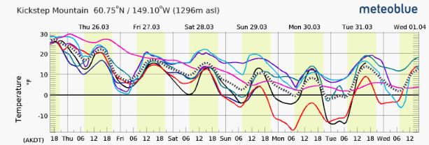
There is excellent agreement between the different models that temperatures will drop and skies will clear over the next couple of days as shown by looking at the forecasts for Kickstep on Meteoblue:

Going into the weekend, a small low in the Gulf of Alaska will produce some clouds and possibly showers, more so closer to the coast. On Windy that low is quite visible:


Finally, as noted in this afternoon's forecast discussion, cold temperatures are likely to stick around for at least another week or two.
Last Week
Our last week is well summarized by the weather record at Sunburst. First, cold temps were pushed out as the wind direction shifted from the north to south.
Then, winds, temps, and humidity peaked with the arrival of the Sunday/Monday storm. It generally has to be windy to snow at Turnagain as most precip there is orthographic where the wind lifts relatively warm air over the Chugach:
Even more wringing out of moisture is produced when the wet/warm air is lifted over cold air. This helped to bring snowfall to Anchorage this week:

Today the Anchorage has been stuck under low clouds because there wasn't enough wind to push out the clouds. Meanwhile its been sunny up above:

Places that had enough wind (like Whittier) to scoop out the low clouds have been sunny too:

Archived Outlook - 1.15.2020
Thurs – Fri: cold, dry, gap winds (high confidence).
Cold temps (but not as cold as its been) will persist with inversions in the usual cold spots. Gap winds in channeled terrain like Whittier, Seward and especially the Mat Valley and Thompson Pass.
Weekend: moderating temps, approaching storm (moderate confidence).
Temps will moderate as high pressure leaves our region. Clouds will arrive ahead of the late Sunday/Monday storm. This storm will favor the coastal areas and there should be no rain concerns.
Early Next Week: moderate temps, snow (low confidence).
After the Sunday/Monday storm wraps up, more snowfall is likely. Timing, strength, and location of the snowfall is uncertain, but at this point it looks like both the coast and interior could get snow. Significant rain concerns are unlikely.
Dirty Details
Cold and clear weather remains over our region. The notable change is that the Mat Valley winds have really kicked up. These winds are stronger than the light gap wind that we have been feeling because they are reinforced by strong upper level northeasterly winds and are impacting Hatcher Pass.

This weekend the weather finally begins to change as the high pressure weakens and moves northeast:
This will bring increasing temps, and will allow a storm to push into Southcentral late Sunday/Monday. This storm will favor areas closer to the coast. Following this storm, more snowfall is likely moving forward in the week. Timing, strength, and location of the snow is up in the air. Below are the precipitation forecasts from the different models for early next week. Their lack of agreement leads to high uncertainty in snowfall, especially for Hatcher.

Last Week
Another awesome week for Southcentral skiers! The cold and clear weather has continued with amazing snow and midwinter light like here on Cornbiscuit the other day:
Inversions continue to be strong, with Sunburst 30 degrees warmer than Granite the other day. Remember, without an inversion, temperatures in a dry atmosphere would decrease at a rate of 3.5 F per 1,000 feet as opposed to INCREASING at 9.3 F per 1,000 feet!

As expected, the winds have jumped up a bit. Particularly notable has been the Mat Valley getting in on the action. Hatcher generally was spared until yesterday, but up high everywhere has seen some wind like Lynx Peak on Saturday:

Thurs – Fri: cold, dry (high confidence).
Cold temps will persist with inversions in the usual cold spots. Valley fog is likely. Gap winds in channeled terrain like Whittier, Seward and especially Thompson Pass.
Weekend: temps increasing, light snow near coast (moderate confidence).
Temperatures will increase over the weekend, snow is possible near the coast Sunday into Monday. No rain concerns. Inland will remain dry. Gap winds in channeled terrain decreasing over weekend.
Early Next Week: dry, moderately cold (moderate confidence).
Temps will generally hold from the weekend. Gap winds in channeled terrain like Whittier, Seward and especially Thompson Pass. Temperature inversions and valley fog in the usual spots.
Dirty Details
We have a few more days of cold weather before temps increase slightly as an small storm brushes against our region later this weekend. This storm has consistently trended later over model runs as can be seen in GFS precipitation output for the Kenai Mountains:

At the same time it has also trended south as shown in this cool modeled precipitation trend animation from Tropical Tidbits:

Moral of the story is that the storm's main impacts will be some cloud cover and possibly light snow near the coast later in the weekend.
Next week will be back to more of the same as cold, dry weather continues in our zone. There is good model agreement that early next week will be dry:

Source: Meteoblue
Looking farther out, it is possible that the dry weather will continue through the work week.
Last Week
Another awesome week for Southcentral skiers! As expected we've been in a period of cold and clear weather. The snow and midwinter light have been amazing, like they were here on the Pinnacle on Saturday:
Photo: Dmitry Surnin
This weather pattern has had some distinct and interesting phenomena. For one, inversions have been strong, with folks seeing temps around -20 F on their way to go skiing. Granite Creek had a particularly notable inversion the other day:

These temp inversions form at night and are driven by cold, dense air flowing downhill while any warmth that is left at the surface escapes into the atmosphere. Without clouds to act as an insulating blanket more energy can escape into the atmosphere. And without winds there isn't much to mix out the inversions. Here's an old textbook graphic of the process:

Another consequence of our cold and clear temps is that snowpacks are faceting. Y'all probably remember this process from avy school, but just like everything else in the world, faceting is driven by gradients. The difference between the relatively warm/wet air in the snow and the cold/dry atmospheric air produces a pressure gradient that drives water vapor through the snowpack and causes snow metamorphism. Avalanche.org has a good description and fun animation of the process:
Finally, gap winds are impacting our region as cold air flows from the interior towards a low in the Gulf. Thompson Pass is experiencing the strongest winds with the NWS forecasting winds up to 40 mph and winds chills as low as -55!! Thompson Pass often experiences the worst of these gap winds because the temperature gradient between the cold Copper River Basin and the warm coast is so large and over a relatively small distance. Like I said, gradients rule us!
Thurs – Fri: clearing, cold (high confidence).
Cold temps will persist with inversions in the usual cold spots (East Anchorage, Portage, Granite Creek, etc). Valley fog is likely.
Weekend: cold, mostly dry (high confidence).
Saturday will be clearer with light snow possible near the coast on Sunday. Cold temps will persist with inversions in the usual cold spots. Valley fog is likely. Gap winds are possible in channeled terrain like Thompson Pass, Whittier, and Seward.
Early Next Week: cold, dry (moderate confidence).
Cold temps will persist with inversions in the usual cold spots. Valley fog is likely. Gap winds are possible in channeled terrain like Thompson Pass, Whittier, and Seward.
Dirty Details
After an exciting and active period of weather, the storm track is finally moving to our south and leaving behind cold and dry weather.

During this period, lows passing thru the Gulf of AK will bring some clouds, wind, and minor snowfall to our region. This is especially true closer to the Prince William Sound.
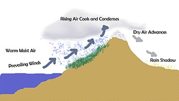
As is the case here when its dry and cold, gap winds could be an issue. These winds can be visualized as water behind a reservoir (cold, dense, high pressure air from the interior) going thru a gap in the dam (wind thru Thompson Pass) and flowing downhill (towards relatively warm and low pressure air in the Gulf of AK). Here's a cool figure from UBC illustrating this:

The gap winds for this period actually look pretty minor, but will be most significant for Seward, Whittier, and Thompson Pass. If the gap winds are worse than expected and impact our main ski areas, the key to skiing during these conditions is to get away from the gaps. For example, gap winds flowing through Turnagain Pass can leave unstable wind slabs on Tincan Proper, while the Library has no slab formation.
This weather pattern could last awhile. Recent GFS model runs for precipitation for the Kenai Mountains show lots of zeros thru next week:

Last Week
Wow! What a week! It started out with expected cold and moist air that brought us blower dendrites. Then, temperatures jumped with the arrival of warm air from the south. By 3 AM yesterday Anchorage had already broken the record temp for December 31! The Anchorage area was significantly warmer than Turnagain Pass due to Chinook winds crashing down on us over the Chugach Mountains. Called "Snow-Eater" by the Blackfeet these warm winds are caused by air that has dropped some of its moisture and rapidly warms as it descends over the mountains. Chinooks are common on the dry-side of mountains all over the Western US such as the Rockies, Sierras, and Cascades. Here's a cool figure of the phenomenon from Accuweather.Then, our New Years cold front arrived and temperatures dropped rapidly. Its pretty cool to see the distinct onset of dropping temperatures with the arrival of the cold air in our local weather stations:

Archived Outlook - 12.25.2019
Thurs – Fri: cold, windy in channeled terrain (high confidence).
The remainder of the work week will be quiet. Temperatures will bottom out (with inversions) on Friday morning before beginning to warm as the next storm arrives Friday afternoon.
Weekend: stormy favoring the coast, cool temps (low confidence).
Snowfall will continue thru the weekend as multiple storms pulse thru. The mountains close to Prince William Sound will be favored, with Valdez looking to do best. Certainty in the timing and strength of these pulses is low. No rain concerns. Colder inland.
Early Next Week: stormy, moderate temps (low confidence).
Snowfall will continue in our zone. Confidence in timing, strength, and location of snowfall is low. Valdez looks to do best with Girdwood, Hatcher, and the Anchorage Front Range all possibly doing well. No rain concerns. Colder inland.
Dirty Details
Thursday will bring significant winds to our channelized terrain as cold, dense air from the interior flows downhill towards the departing low pressure in the Gulf of Alaska. These winds will impact Turnagain Arm, Turnagain Pass, Seward, Whittier, and Valdez as seen on Windy:

On Friday afternoon the next storm hits our mountains. This storm won't be huge, but the cold air should help to wring out a good amount of low density snow that will help to build up the snowpack at low elevations. Additional waves should arrive on Saturday and again Sunday. There is low confidence in these storms due to poor agreement between models as shown in the varying precipitation forecasts for Kickstep:

Source: Meteoblue.
Going into next week, forecast confidence is low. The highest confidence is for the Valdez area where models are showing agreement on continued snowfall:

Source: Meteoblue.
I'm going to get myself into trouble with this, but looking out into late next week there is the chance of drying weather. This is shown in GFS model output (each column is one model run) of the water equivalent forecast for the Kenai Mountains:

Again, this is a LONG time out. And there is disagreement between model runs about when and if drying will occur. If it does, expect plunging temps, winds in channeled terrain, and rapidly faceting snow.
Last Week
Christmas came early last week with an absolutely incredible weather window at Turnagain. Not only was the snow good, it was stable, and sunny. It blows me away just how good our backcountry skiing can be. Here's Connor Johnson on Friday ripping spines in the golden hour:
The clouds came in earlier on Sunday than I expected. In retrospect, this should have been reflected in a lower confidence for my weekend forecast. On the bright side, the clouds brought a refresh of blower snow for the beginning of this week. That blower snow is a function of temperature and humidity, as shown in the chart below:
The huge dendrites at the top of the figure are formed when cold, moist air coming off of places like the Great Salt (or the Sea of Japan) dumps feet of low density snow in Little Cottonwood Canyon (or Hokkaido). Turnagain often experiences the denser dendrites on the left side of the figure due to warmer air from the Gulf of Alaska. Our recent colder temperatures are much better for producing that cold smoke we crave!
Archived Outlook - 12.18.2019
Thurs – Fri: dropping temps, clearing skies, windy in channeled terrain (high confidence).
Temperatures drop as winds switch from blowing off of the ocean to out of the Arctic. The usual suspects like Granite Creek and East Anchorage will have temp inversions. Moderate winds through gaps especially Seward, Thompson Pass, and the Copper River. Limited fog is possible.
Weekend: cold, clear, windy in channel terrain (high confidence).
Temps continue to drop. Inversions persist. Outflow winds continue. Limited fog possible.
Early Next Week: moderating temps, dry inland, light snow near coast (low confidence).
Temperatures will moderate as low pressure enters the Gulf of AK. Confidence about precipitation timing and amount is low. But, expect light precipitation and low rain/snow lines for Turnagain/Girdwood.
Dirty Details
Temperatures will start to drop tomorrow as the wind direction finally switches from bringing warm air off the north Pacific to bringing cold, dry air from the Arctic. This is nicely shown on Windy's upper atmosphere wind forecast for Friday:

There is high confidence in this clear/cold weather because there is good run-to-run model agreement and good agreement between models. We can see the agreement between models for Kickstep on Meteoblue:

These cold temps will bring outflow winds. How strong the winds are is the uncertainty for skiers through the weekend. The winds are driven by cold, dense, high pressure air from the interior flowing "downhill" towards the relatively warm, low density, air over the Gulf of Alaska. They are lazy and follow corridors to the coast. For this weekend, areas that will be most affected are Thompson Pass, Cordova, Seward, and the Matanuska Valley. Turnagain Pass will be impacted to a lesser extent. The key to avoiding these winds is to get away from the paths they like to take. Areas that will see the most wind are shown below with Windy's wind accumulation parameter:

Early next week areas close to the coast will likely see snowfall and the associated rising temps of warmer air off the Pacific. There is low model agreement about this both in terms of strength and timing, but don't expect anything big. Meanwhile, there is high confidence that inland will stay dry as shown by the consistent zero-precipitation forecast for the Susitna Valley:

Last Week
Our region has been in a repeating pattern of weak storms in the Gulf of AK bringing moderate snow to Turnagain and coastal areas. This pattern is visible on the Sunburst weather station record as sustained northeasterly winds and high relative humidity:
Despite the series of storms that have hit the Kenai Mountains, there is no snow down low. A quick look at the below-average Kenai SNOTELs tells the story of the warm weather we have been experiencing:


Temperatures have also slowly been trending down:

As skies continue to clear, and winds switch to the north that downward temperature trend is about to significantly accelerate!
Archived Outlook - 12.11.2019
Thurs – Fri: moderate temps, moderate precip near coast, dry inland (high confidence).
Moderate precipitation will fall at Turnagain Pass and closer to the coast while the inland stays dry. The rain/snow line will be near the road at Turnagain. The high peaks of Turnagain will receive 2 feet of snow with minimal accumulation at the road.
Weekend: moderate temps, moderate precip near coast, dry inland (moderate confidence).
Saturday will be in between storms before another storm arrives for Sunday. The rain/snow line will be near the road. The inland will be downsloped and dry.
Early Next Week: moderate temps, dry inland, potentially drying (low confidence).
Sunday's western PWS storm will likely continue into Monday, with clearing/drying possible Tuesday into Wednesday. The inland will be dry. Temperatures should drop a bit.
Dirty Details
There is high confidence in dry weather over the interior of our region over the next week as exemplified by consistent GFS run-to-run model output for Talkeetna:

While the interior is downsloped, areas closer to the coast will pick up precipitation as is clearly seen in the long-term water equivalent forecast for our zone. As is classic when the wind blows from the southeast, areas closest to the western Prince William Sound do the best.

The exact timing and strength of the Sunday/Monday storm is uncertain due to disagreement in timing/strength between the models:

There is good agreement that over the next week temperatures will slowly drop as can be seen by the Meteoblue model ensemble graph for Turnagain Pass:

Last Week
The last week started with rising temps as the flow direction shifted from north to south over our zone. Areas closest to the coast clouded up first followed by Hatcher Pass by the weekend. The weekend was stormy as multiple warm storms produced rain/snow close to the coast (Portage/Turnagain/Girdwood/Seward) while inland got wind, wind, wind. Monday's big storm left relatively warm temps in its wake. The before, during, and after are exemplified nicely in the Marmot Wx Station:
At Hatcher the weekend's story was wind slabs on top of the surface hoar formed by our last period of cold, clear, and high humidity. This led to lots of skier triggered avalanches. I was briefly caught in one before self-arresting, and so did everyone's friend Edskimo:
Meanwhile, areas closer to the coast were getting hammered with copious amounts of precipitation and high snow lines. Rain on snow produced big peaks in area hydrographs, like this one on Sixmile Creek:


Thurs – Fri: rising temps, skies becoming cloudy (high confidence).
Temperatures will rise as the wind direction shifts from the north. With this shift expect cloud cover to increase and snow showers by the end of the work week. Areas closest to the Prince William Sound (PWS) will be impacted the most.
Weekend: stormy, warm, windy (moderate confidence).
Precipitation will begin in earnest on Saturday night favoring areas closest to the PWS with the interior in the shadow. Rain lines will rise to the alpine for Turnagain/Girdwood/Seward. All areas will be windy.
Early Next Week: stormy, warm, windy (moderate confidence).
The stormy pattern favoring areas closest to the PWS will continue. Rain lines will be high. All areas will be windy.
Dirty Details
There is good agreement between the models that the next series of storms will arrive to the Gulf Coast late on Saturday. This is exemplified by model output of accumulated precipitation for Kickstep Mountain at Turnagain Pass:

By Monday morning the peaks above Turnagain/Girdwood/Seward will receive 3+ feet of snow. There will be tight elevation gradients with lower elevations receiving wet/heavy snow and rain. Storminess will continue (and will continue to favor the coastal zones) into next week. However, timing of next week's storms is lower as can be seen by the difference between the models. For example, model output for Kickstep Mountain:

Timing is uncertain, but its going to precipitate a lot. 10 day forecasts are never great, but here is the 10 day snowfall forecast from the ECMWF. Its classic for southeast flow. The western PWS will get copious precip. The Neacolas and Tordrillos also do well. Meanwhile, the Anchorage Front Range and Talkeetnas will be in the shadow of the High Chugach.

Last Week
The arrival of last week's warm, wet, and windy storm was visible as rising temps (and wind, and humidity), on area weather stations:
By early this week the Hatcher Pass SNOTEL was approaching the SWE content that it normally peaks at each May:

Independence Mine is now at 311% of median (w/ Tony D reporting 8 feet of snow at Birthday Pass!!!), the Peters Hills are at 264% of median, and the Anchorage Front Range is even a bit above average. Like we discussed last week, these warm storms really hit the Kenai hard, and although the SNOTELS down there did pick up to two inches of water, it fell as rain down low.
As the storms cleared early this week, calmer winds, clear skies, and cold temps arrived. However, humidity remained high. Clear skies, cold temps, and high humidity are a great recipe for surface hoar formation.
Archived Outlook - 11.27.2019
Thurs – Fri: stormy, windy, warm temps (high confidence).
The advertised storm is already upon us; precipitation and winds will peak tonight/tomorrow. The rain line will rise above the Turnagain Pass road level; there will be no rain concerns for Hatcher. On Friday, lighter precipitation will continue closer to the Prince William Sound, while Hatcher will see clouds/snow showers. Storm totals for Hatcher and the Turnagain/Girdwood alpine will exceed 3 feet and could reach 5 feet. The Peters Hills, Thompson Pass, and Anchorage Front Range will do well.
Weekend: cloudy to stormy, moderate temps (moderate confidence).
Saturday will be a cloudy and showery in-between day before another storm moves in Saturday night. This storm will favor areas closer to the Prince William Sound with 9" to 18" of snow and less as you move away from the coast. The weekend storm should not have high rain line issues.
Early Next Week: stormy to clearing, cooling temps (high confidence).
The weekend storm will move out of our area on Monday. Behind it temperatures will dramatically fall and skies will clear. Expect moderate outflow winds.
Dirty Details
There is high confidence about our Thanksgiving storm due to good agreement both between different models and from run-to-run. For example, below is consistent run-to-run QPF (multiply X10 to estimate snowfall) model output for the mountains around the Western Prince William Sound (source wxweb.meteostar.com).


This big, wet, warm storm is courtesy of a giant tap of tropical moisture getting lifted by the jet stream over the cold air in place in our mountains. Because this storm is blowing in from the southwest, it will allow all areas to receive snowfall (source Windy.com).

On Friday, the upper level wind direction will shift to the southeast, which allow precipitation to continue for mountains around the Western Prince William Sound, but will put Hatcher in the shadow of the Chugach Mountains:

The weekend's storm will not be as strong or as warm partly because it will not have the same jet stream support as the Thanksgiving storm; the jet stream will be to our south and it will be blowing from the west instead of the south.

Early next week temperatures will drop and skies will trend clearer as the Sunday storm leaves our area and cold, dry air from the north moves in. There is high confidence in this dry, cold period as seen in strong run-to-run GFS model agreement in the QPF output for the Kenai Mountains:

Last Week
After last weekend at Hatcher its hard for us skiers in Southcentral AK to be anything but stoked about how the season is starting out. With huge stellar dendrites falling from the blue sky and blower snow it felt like Japan! Here's a favorite weekend moment of mine:
The Hatcher Pass SNOTEL is at 250% of its median SWE for this date (median for March 8th)! The Thompson Pass SNOTEL is doing even better at 330% of median SWE!!! The Kenai Mountains and Girdwood Valley which are particularly susceptible to rain have struggled with SWE at area SNOTELS as low as 7%. But, hopefully that's about to turn around too!
No comments:
Post a Comment